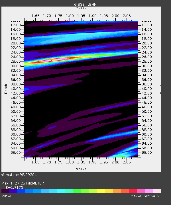
SSB Saint Sauveur Badole, France - Earthquake Result Viewer
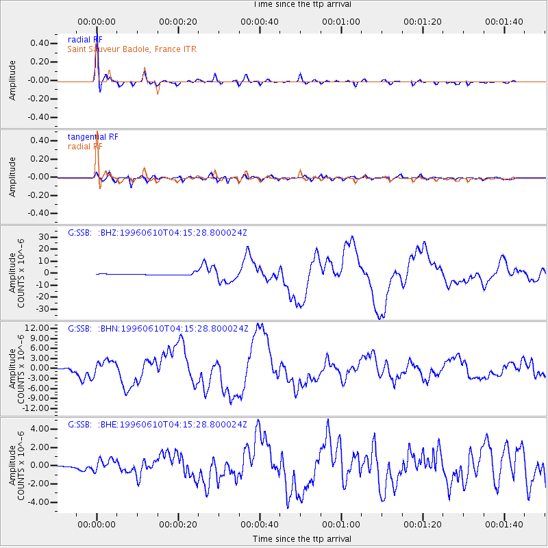
Earthquake location: Andreanof Islands, Aleutian Is.
Earthquake latitude/longitude: 51.6/-177.6
Earthquake time(UTC): 1996/06/10 (162) 04:03:35 GMT
Earthquake Depth: 33 km
Earthquake Magnitude: 6.6 MB, 7.6 MS, 7.9 UNKNOWN, 7.4 MS
Earthquake Catalog/Contributor: WHDF/NEIC
Network: G GEOSCOPE
Station: SSB Saint Sauveur Badole, France
Lat/Lon: 45.28 N/4.54 E
Elevation: 700 m
Distance: 83.5 deg
Az: 358.455 deg
Baz: 1.366 deg
Ray Param: 0.046086613
Estimated Moho Depth: 27.25 km
Estimated Crust Vp/Vs: 1.72
Assumed Crust Vp: 6.1 km/s
Estimated Crust Vs: 3.552 km/s
Estimated Crust Poisson's Ratio: 0.24
Radial Match: 98.29394 %
Radial Bump: 349
Transverse Match: 90.7217 %
Transverse Bump: 400
SOD ConfigId: 6273
Insert Time: 2010-02-27 00:10:11.475 +0000
GWidth: 2.5
Max Bumps: 400
Tol: 0.001

Signal To Noise

ChannelStoNSTALTA
G:SSB: :BHN:19960610T04:15:28.800024Z9.8254792.2858678E-62.3264697E-7
G:SSB: :BHE:19960610T04:15:28.800024Z9.5776996.572414E-76.862206E-8
G:SSB: :BHZ:19960610T04:15:28.800024Z8.3873685.740658E-66.844409E-7
Arrivals
Ps3.3 SECOND
PpPs12 SECOND
PsPs/PpSs15 SECOND