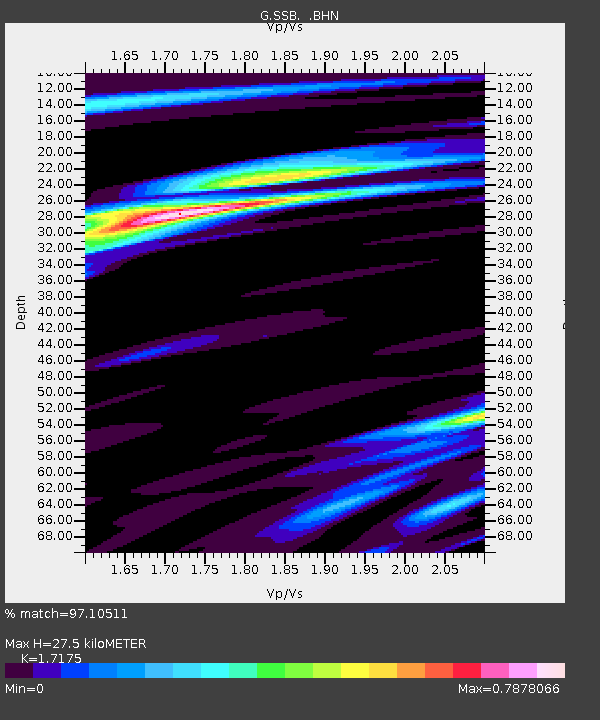
SSB Saint Sauveur Badole, France - Earthquake Result Viewer

Earthquake location: Northern Mid-Atlantic Ridge
Earthquake latitude/longitude: 10.8/-42.3
Earthquake time(UTC): 1996/06/02 (154) 02:52:09 GMT
Earthquake Depth: 10 km
Earthquake Magnitude: 6.1 MB, 6.9 MS, 7.0 UNKNOWN, 6.8 MW
Earthquake Catalog/Contributor: WHDF/NEIC
Network: G GEOSCOPE
Station: SSB Saint Sauveur Badole, France
Lat/Lon: 45.28 N/4.54 E
Elevation: 700 m
Distance: 52.6 deg
Az: 40.347 deg
Baz: 244.283 deg
Ray Param: 0.06662517
Estimated Moho Depth: 27.5 km
Estimated Crust Vp/Vs: 1.72
Assumed Crust Vp: 6.1 km/s
Estimated Crust Vs: 3.552 km/s
Estimated Crust Poisson's Ratio: 0.24
Radial Match: 97.10511 %
Radial Bump: 324
Transverse Match: 83.4918 %
Transverse Bump: 400
SOD ConfigId: 6273
Insert Time: 2010-02-27 00:10:13.962 +0000
GWidth: 2.5
Max Bumps: 400
Tol: 0.001

Signal To Noise

ChannelStoNSTALTA
G:SSB: :BHN:19960602T03:00:52.700012Z21.2113342.8396848E-61.3387582E-7
G:SSB: :BHE:19960602T03:00:52.700012Z46.19575.807115E-61.2570683E-7
G:SSB: :BHZ:19960602T03:00:52.700012Z51.636671.4420872E-52.792758E-7
Arrivals
Ps3.4 SECOND
PpPs12 SECOND
PsPs/PpSs15 SECOND