You are here: Home > Network List > TA - USArray Transportable Network (new EarthScope stations) Stations List
> Station Q48A North Vernon, IN, USA > Earthquake Result Viewer
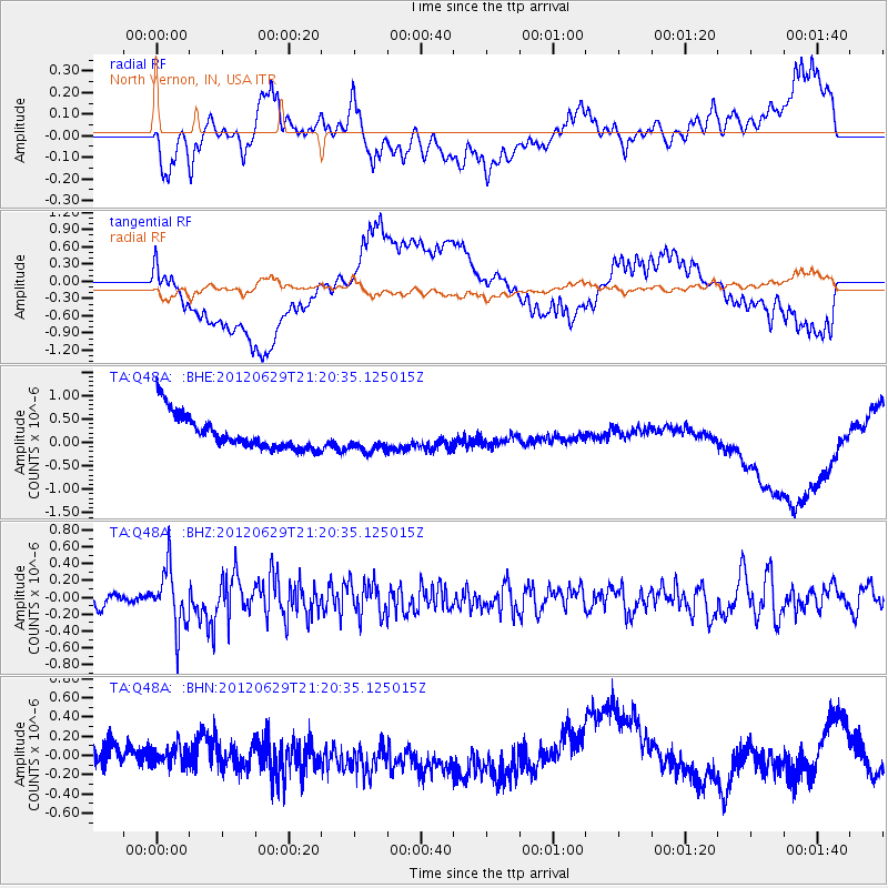
Q48A North Vernon, IN, USA - Earthquake Result Viewer
*The percent match for this event was below the threshold and hence no stack was calculated.
| Earthquake location: |
Northern Xinjiang, China |
| Earthquake latitude/longitude: |
43.4/84.7 |
| Earthquake time(UTC): |
2012/06/29 (181) 21:07:33 GMT |
| Earthquake Depth: |
18 km |
| Earthquake Magnitude: |
6.2 MB, 6.4 MS, 6.3 MW, 6.3 MW |
| Earthquake Catalog/Contributor: |
WHDF/NEIC |
|
| Network: |
TA USArray Transportable Network (new EarthScope stations) |
| Station: |
Q48A North Vernon, IN, USA |
| Lat/Lon: |
38.93 N/85.73 W |
| Elevation: |
185 m |
|
| Distance: |
97.6 deg |
| Az: |
352.484 deg |
| Baz: |
7.017 deg |
| Ray Param: |
$rayparam |
*The percent match for this event was below the threshold and hence was not used in the summary stack. |
|
| Radial Match: |
35.456596 % |
| Radial Bump: |
400 |
| Transverse Match: |
41.311295 % |
| Transverse Bump: |
400 |
| SOD ConfigId: |
463687 |
| Insert Time: |
2013-02-20 17:29:48.115 +0000 |
| GWidth: |
2.5 |
| Max Bumps: |
400 |
| Tol: |
0.001 |
|
Signal To Noise
| Channel | StoN | STA | LTA |
| TA:Q48A: :BHZ:20120629T21:20:35.125015Z | 3.3246086 | 3.455469E-7 | 1.0393611E-7 |
| TA:Q48A: :BHN:20120629T21:20:35.125015Z | 0.8284248 | 1.3743401E-7 | 1.65898E-7 |
| TA:Q48A: :BHE:20120629T21:20:35.125015Z | 0.82894593 | 2.9825947E-7 | 3.598057E-7 |
| Arrivals |
| Ps | |
| PpPs | |
| PsPs/PpSs | |


