You are here: Home > Network List > UW - Pacific Northwest Regional Seismic Network Stations List
> Station LEBA Lebam, WA, USA > Earthquake Result Viewer
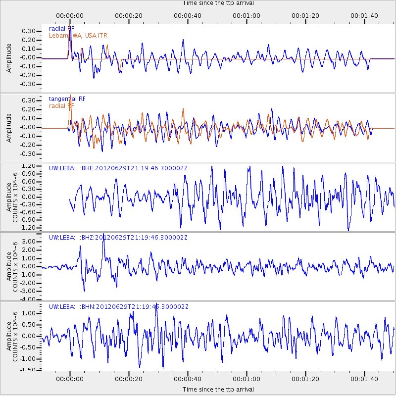
LEBA Lebam, WA, USA - Earthquake Result Viewer
*The percent match for this event was below the threshold and hence no stack was calculated.
| Earthquake location: |
Northern Xinjiang, China |
| Earthquake latitude/longitude: |
43.4/84.7 |
| Earthquake time(UTC): |
2012/06/29 (181) 21:07:33 GMT |
| Earthquake Depth: |
18 km |
| Earthquake Magnitude: |
6.2 MB, 6.4 MS, 6.3 MW, 6.3 MW |
| Earthquake Catalog/Contributor: |
WHDF/NEIC |
|
| Network: |
UW Pacific Northwest Regional Seismic Network |
| Station: |
LEBA Lebam, WA, USA |
| Lat/Lon: |
46.55 N/123.56 W |
| Elevation: |
73 m |
|
| Distance: |
87.0 deg |
| Az: |
19.104 deg |
| Baz: |
339.792 deg |
| Ray Param: |
$rayparam |
*The percent match for this event was below the threshold and hence was not used in the summary stack. |
|
| Radial Match: |
76.89942 % |
| Radial Bump: |
400 |
| Transverse Match: |
67.80556 % |
| Transverse Bump: |
400 |
| SOD ConfigId: |
463687 |
| Insert Time: |
2013-02-20 17:32:28.434 +0000 |
| GWidth: |
2.5 |
| Max Bumps: |
400 |
| Tol: |
0.001 |
|
Signal To Noise
| Channel | StoN | STA | LTA |
| UW:LEBA: :BHZ:20120629T21:19:46.300002Z | 7.325209 | 1.0556126E-6 | 1.4410682E-7 |
| UW:LEBA: :BHN:20120629T21:19:46.300002Z | 1.4648149 | 4.9292356E-7 | 3.365091E-7 |
| UW:LEBA: :BHE:20120629T21:19:46.300002Z | 0.55144393 | 1.7481031E-7 | 3.1700466E-7 |
| Arrivals |
| Ps | |
| PpPs | |
| PsPs/PpSs | |


