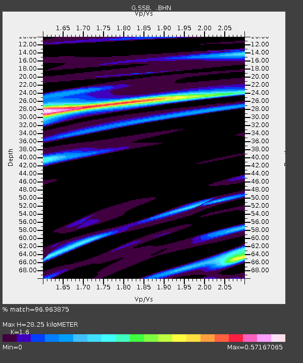
SSB Saint Sauveur Badole, France - Earthquake Result Viewer

Earthquake location: Off East Coast Of Kamchatka
Earthquake latitude/longitude: 51.6/159.1
Earthquake time(UTC): 1996/06/21 (173) 13:57:10 GMT
Earthquake Depth: 20 km
Earthquake Magnitude: 6.0 MB, 6.6 MS, 7.0 UNKNOWN, 6.5 MS
Earthquake Catalog/Contributor: WHDF/NEIC
Network: G GEOSCOPE
Station: SSB Saint Sauveur Badole, France
Lat/Lon: 45.28 N/4.54 E
Elevation: 700 m
Distance: 81.1 deg
Az: 342.132 deg
Baz: 15.738 deg
Ray Param: 0.04783005
Estimated Moho Depth: 28.25 km
Estimated Crust Vp/Vs: 1.60
Assumed Crust Vp: 6.1 km/s
Estimated Crust Vs: 3.812 km/s
Estimated Crust Poisson's Ratio: 0.18
Radial Match: 96.963875 %
Radial Bump: 314
Transverse Match: 89.52273 %
Transverse Bump: 400
SOD ConfigId: 6273
Insert Time: 2010-02-27 00:10:41.504 +0000
GWidth: 2.5
Max Bumps: 400
Tol: 0.001

Signal To Noise

ChannelStoNSTALTA
G:SSB: :BHN:19960621T14:08:52.200012Z19.108282.7705141E-61.4499024E-7
G:SSB: :BHE:19960621T14:08:52.200012Z17.3783251.2861734E-67.40102E-8
G:SSB: :BHZ:19960621T14:08:52.200012Z19.1940566.8045797E-63.5451495E-7
Arrivals
Ps2.9 SECOND
PpPs12 SECOND
PsPs/PpSs15 SECOND