You are here: Home > Network List > G - GEOSCOPE Stations List
> Station SSB Saint Sauveur Badole, France > Earthquake Result Viewer
SSB Saint Sauveur Badole, France - Earthquake Result Viewer
| Earthquake location: |
Southern India |
| Earthquake latitude/longitude: |
23.1/80.0 |
| Earthquake time(UTC): |
1997/05/21 (141) 22:51:28 GMT |
| Earthquake Depth: |
36 km |
| Earthquake Magnitude: |
6.0 MB, 5.6 MS, 5.8 UNKNOWN, 5.6 ME |
| Earthquake Catalog/Contributor: |
WHDF/NEIC |
|
| Network: |
G GEOSCOPE |
| Station: |
SSB Saint Sauveur Badole, France |
| Lat/Lon: |
45.28 N/4.54 E |
| Elevation: |
700 m |
|
| Distance: |
64.0 deg |
| Az: |
310.472 deg |
| Baz: |
82.843 deg |
| Ray Param: |
0.05916689 |
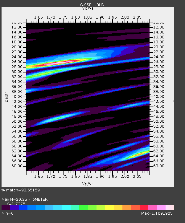
| Estimated Moho Depth: |
26.25 km |
| Estimated Crust Vp/Vs: |
1.73 |
| Assumed Crust Vp: |
6.1 km/s |
| Estimated Crust Vs: |
3.531 km/s |
| Estimated Crust Poisson's Ratio: |
0.25 |
|
| Radial Match: |
90.55159 % |
| Radial Bump: |
400 |
| Transverse Match: |
77.09973 % |
| Transverse Bump: |
400 |
| SOD ConfigId: |
6273 |
| Insert Time: |
2010-02-27 00:11:00.357 +0000 |
| GWidth: |
2.5 |
| Max Bumps: |
400 |
| Tol: |
0.001 |
|
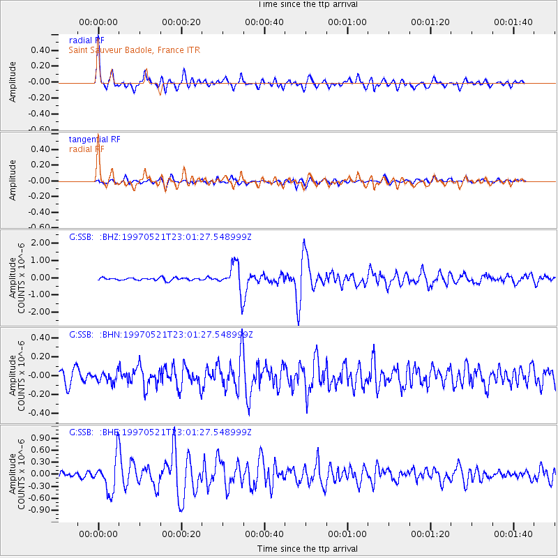
Signal To Noise
| Channel | StoN | STA | LTA |
| G:SSB: :BHN:19970521T23:01:27.548999Z | 0.7318142 | 5.169636E-8 | 7.064138E-8 |
| G:SSB: :BHE:19970521T23:01:27.548999Z | 4.995522 | 4.4723794E-7 | 8.952777E-8 |
| G:SSB: :BHZ:19970521T23:01:27.548999Z | 11.63487 | 8.5200617E-7 | 7.3228684E-8 |
| Arrivals |
| Ps | 3.3 SECOND |
| PpPs | 11 SECOND |
| PsPs/PpSs | 15 SECOND |


