You are here: Home > Network List > G - GEOSCOPE Stations List
> Station SSB Saint Sauveur Badole, France > Earthquake Result Viewer
SSB Saint Sauveur Badole, France - Earthquake Result Viewer
| Earthquake location: |
Guerrero, Mexico |
| Earthquake latitude/longitude: |
18.7/-101.6 |
| Earthquake time(UTC): |
1997/05/22 (142) 07:50:53 GMT |
| Earthquake Depth: |
70 km |
| Earthquake Magnitude: |
5.9 MB, 6.0 MS, 6.6 UNKNOWN, 6.5 MW |
| Earthquake Catalog/Contributor: |
WHDF/NEIC |
|
| Network: |
G GEOSCOPE |
| Station: |
SSB Saint Sauveur Badole, France |
| Lat/Lon: |
45.28 N/4.54 E |
| Elevation: |
700 m |
|
| Distance: |
87.7 deg |
| Az: |
42.743 deg |
| Baz: |
294.319 deg |
| Ray Param: |
0.042968694 |
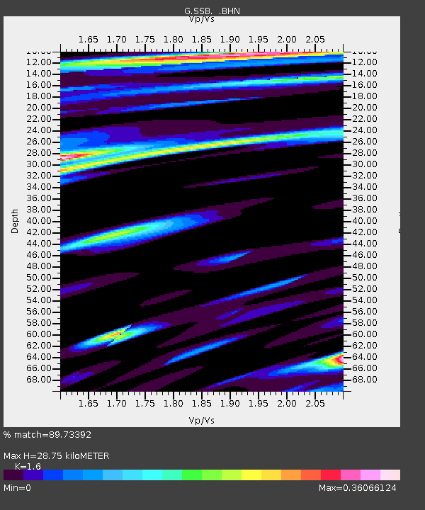
| Estimated Moho Depth: |
28.75 km |
| Estimated Crust Vp/Vs: |
1.60 |
| Assumed Crust Vp: |
6.1 km/s |
| Estimated Crust Vs: |
3.812 km/s |
| Estimated Crust Poisson's Ratio: |
0.18 |
|
| Radial Match: |
89.73392 % |
| Radial Bump: |
400 |
| Transverse Match: |
69.28767 % |
| Transverse Bump: |
400 |
| SOD ConfigId: |
6273 |
| Insert Time: |
2010-02-27 00:11:01.665 +0000 |
| GWidth: |
2.5 |
| Max Bumps: |
400 |
| Tol: |
0.001 |
|

Signal To Noise
| Channel | StoN | STA | LTA |
| G:SSB: :BHN:19970522T08:03:03.500Z | 2.0584698 | 1.7234134E-7 | 8.3723044E-8 |
| G:SSB: :BHE:19970522T08:03:03.500Z | 4.175937 | 2.3681936E-7 | 5.6710473E-8 |
| G:SSB: :BHZ:19970522T08:03:03.500Z | 8.258582 | 9.782503E-7 | 1.1845259E-7 |
| Arrivals |
| Ps | 2.9 SECOND |
| PpPs | 12 SECOND |
| PsPs/PpSs | 15 SECOND |


