You are here: Home > Network List > G - GEOSCOPE Stations List
> Station SSB Saint Sauveur Badole, France > Earthquake Result Viewer
SSB Saint Sauveur Badole, France - Earthquake Result Viewer
| Earthquake location: |
Near Coast Of Venezuela |
| Earthquake latitude/longitude: |
10.6/-63.5 |
| Earthquake time(UTC): |
1997/07/09 (190) 19:24:13 GMT |
| Earthquake Depth: |
20 km |
| Earthquake Magnitude: |
6.2 MB, 6.8 MS, 7.0 UNKNOWN, 6.6 ME |
| Earthquake Catalog/Contributor: |
WHDF/NEIC |
|
| Network: |
G GEOSCOPE |
| Station: |
SSB Saint Sauveur Badole, France |
| Lat/Lon: |
45.28 N/4.54 E |
| Elevation: |
700 m |
|
| Distance: |
67.1 deg |
| Az: |
45.298 deg |
| Baz: |
261.793 deg |
| Ray Param: |
0.057155944 |
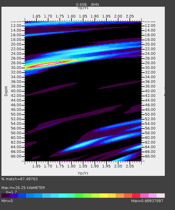
| Estimated Moho Depth: |
28.25 km |
| Estimated Crust Vp/Vs: |
1.70 |
| Assumed Crust Vp: |
6.1 km/s |
| Estimated Crust Vs: |
3.588 km/s |
| Estimated Crust Poisson's Ratio: |
0.24 |
|
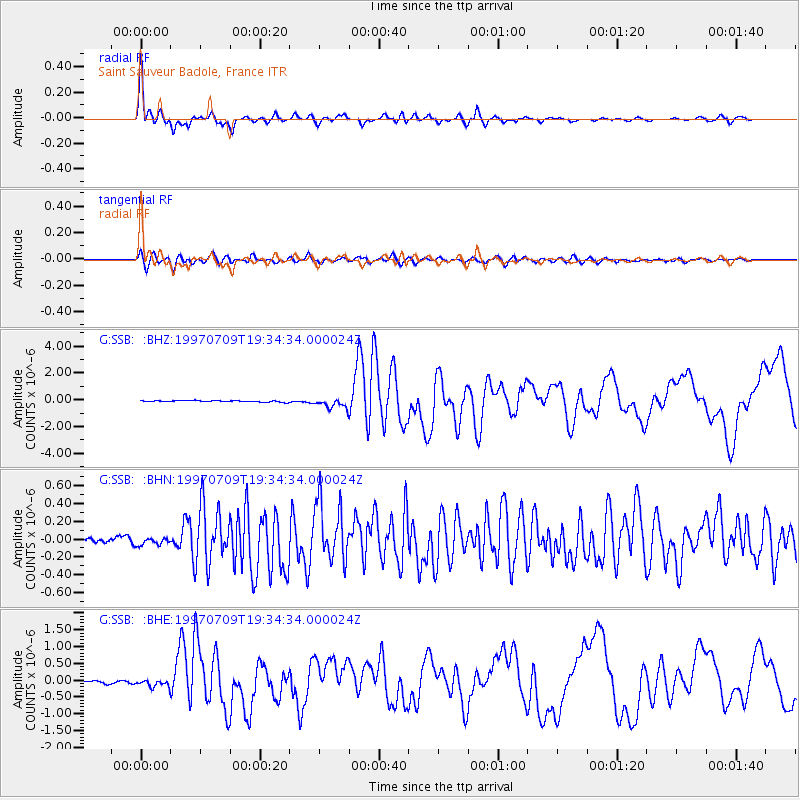
| Radial Match: |
97.49783 % |
| Radial Bump: |
336 |
| Transverse Match: |
90.30935 % |
| Transverse Bump: |
400 |
| SOD ConfigId: |
6273 |
| Insert Time: |
2010-02-27 00:11:05.474 +0000 |
| GWidth: |
2.5 |
| Max Bumps: |
400 |
| Tol: |
0.001 |
|
Signal To Noise
| Channel | StoN | STA | LTA |
| G:SSB: :BHN:19970709T19:34:34.000024Z | 1.6115384 | 4.257876E-8 | 2.6421189E-8 |
| G:SSB: :BHE:19970709T19:34:34.000024Z | 3.389157 | 1.2095705E-7 | 3.568942E-8 |
| G:SSB: :BHZ:19970709T19:34:34.000024Z | 7.1756897 | 3.7235202E-7 | 5.1890765E-8 |
| Arrivals |
| Ps | 3.4 SECOND |
| PpPs | 12 SECOND |
| PsPs/PpSs | 15 SECOND |


