You are here: Home > Network List > TA - USArray Transportable Network (new EarthScope stations) Stations List
> Station C37A Embarrass, MN, USA > Earthquake Result Viewer
C37A Embarrass, MN, USA - Earthquake Result Viewer
| Earthquake location: |
Near Coast Of Peru |
| Earthquake latitude/longitude: |
-14.4/-75.6 |
| Earthquake time(UTC): |
2012/07/02 (184) 23:31:37 GMT |
| Earthquake Depth: |
40 km |
| Earthquake Magnitude: |
6.0 MB, 5.2 MS, 5.7 MW, 5.6 MW |
| Earthquake Catalog/Contributor: |
WHDF/NEIC |
|
| Network: |
TA USArray Transportable Network (new EarthScope stations) |
| Station: |
C37A Embarrass, MN, USA |
| Lat/Lon: |
47.73 N/92.19 W |
| Elevation: |
447 m |
|
| Distance: |
63.6 deg |
| Az: |
347.577 deg |
| Baz: |
162.017 deg |
| Ray Param: |
0.059384108 |
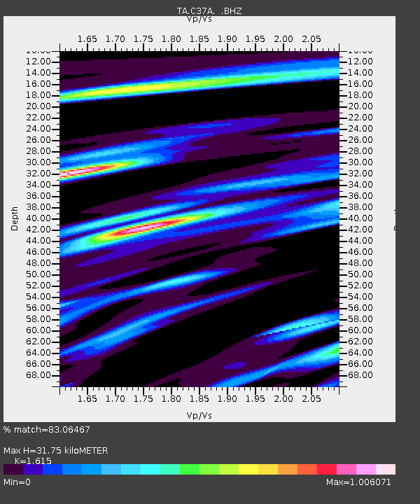
| Estimated Moho Depth: |
31.75 km |
| Estimated Crust Vp/Vs: |
1.62 |
| Assumed Crust Vp: |
6.571 km/s |
| Estimated Crust Vs: |
4.069 km/s |
| Estimated Crust Poisson's Ratio: |
0.19 |
|
| Radial Match: |
83.06467 % |
| Radial Bump: |
400 |
| Transverse Match: |
75.20947 % |
| Transverse Bump: |
400 |
| SOD ConfigId: |
463687 |
| Insert Time: |
2013-02-20 18:05:42.045 +0000 |
| GWidth: |
2.5 |
| Max Bumps: |
400 |
| Tol: |
0.001 |
|

Signal To Noise
| Channel | StoN | STA | LTA |
| TA:C37A: :BHZ:20120702T23:41:34.074978Z | 8.52765 | 5.924752E-7 | 6.947696E-8 |
| TA:C37A: :BHN:20120702T23:41:34.074978Z | 2.8143327 | 2.1957898E-7 | 7.8021685E-8 |
| TA:C37A: :BHE:20120702T23:41:34.074978Z | 1.5748798 | 1.12151454E-7 | 7.121271E-8 |
| Arrivals |
| Ps | 3.1 SECOND |
| PpPs | 12 SECOND |
| PsPs/PpSs | 15 SECOND |


