You are here: Home > Network List > TA - USArray Transportable Network (new EarthScope stations) Stations List
> Station N37A Lee Faris, Mount Ayr, IA, USA > Earthquake Result Viewer
N37A Lee Faris, Mount Ayr, IA, USA - Earthquake Result Viewer
| Earthquake location: |
Near Coast Of Peru |
| Earthquake latitude/longitude: |
-14.4/-75.6 |
| Earthquake time(UTC): |
2012/07/02 (184) 23:31:37 GMT |
| Earthquake Depth: |
40 km |
| Earthquake Magnitude: |
6.0 MB, 5.2 MS, 5.7 MW, 5.6 MW |
| Earthquake Catalog/Contributor: |
WHDF/NEIC |
|
| Network: |
TA USArray Transportable Network (new EarthScope stations) |
| Station: |
N37A Lee Faris, Mount Ayr, IA, USA |
| Lat/Lon: |
40.76 N/94.21 W |
| Elevation: |
351 m |
|
| Distance: |
57.6 deg |
| Az: |
343.304 deg |
| Baz: |
158.505 deg |
| Ray Param: |
0.0633402 |
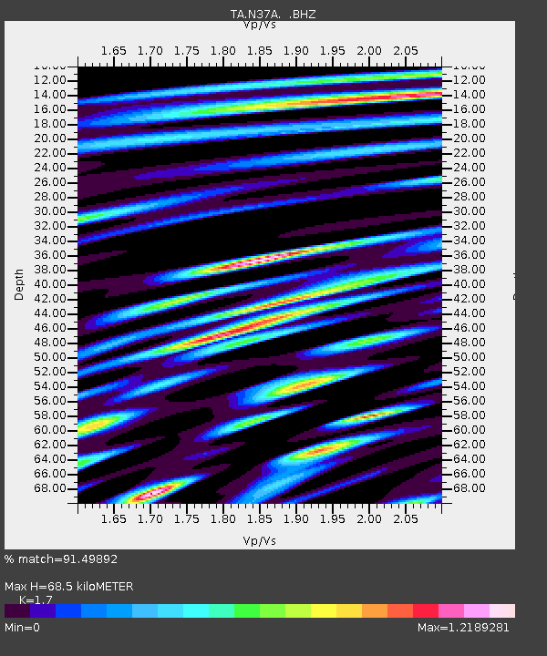
| Estimated Moho Depth: |
68.5 km |
| Estimated Crust Vp/Vs: |
1.70 |
| Assumed Crust Vp: |
6.498 km/s |
| Estimated Crust Vs: |
3.822 km/s |
| Estimated Crust Poisson's Ratio: |
0.24 |
|
| Radial Match: |
91.49892 % |
| Radial Bump: |
400 |
| Transverse Match: |
80.52795 % |
| Transverse Bump: |
400 |
| SOD ConfigId: |
463687 |
| Insert Time: |
2013-02-20 18:07:13.778 +0000 |
| GWidth: |
2.5 |
| Max Bumps: |
400 |
| Tol: |
0.001 |
|

Signal To Noise
| Channel | StoN | STA | LTA |
| TA:N37A: :BHZ:20120702T23:40:52.800015Z | 5.5932426 | 6.998985E-7 | 1.2513287E-7 |
| TA:N37A: :BHN:20120702T23:40:52.800015Z | 3.1987884 | 4.96882E-7 | 1.5533443E-7 |
| TA:N37A: :BHE:20120702T23:40:52.800015Z | 1.9801853 | 2.5295674E-7 | 1.2774397E-7 |
| Arrivals |
| Ps | 7.8 SECOND |
| PpPs | 27 SECOND |
| PsPs/PpSs | 35 SECOND |


