You are here: Home > Network List > G - GEOSCOPE Stations List
> Station SSB Saint Sauveur Badole, France > Earthquake Result Viewer
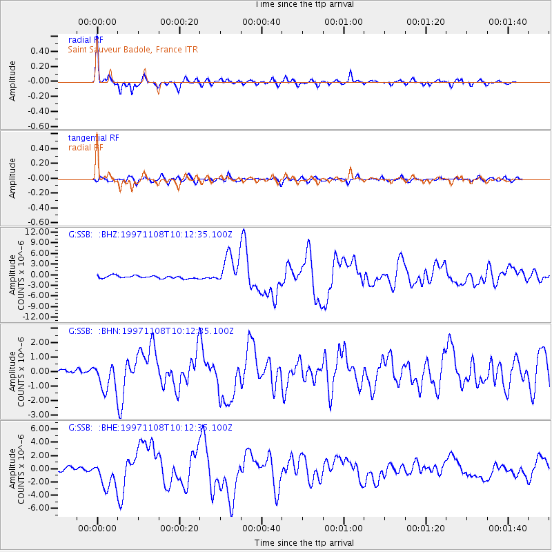
SSB Saint Sauveur Badole, France - Earthquake Result Viewer

| Earthquake location: |
Xizang |
| Earthquake latitude/longitude: |
35.1/87.3 |
| Earthquake time(UTC): |
1997/11/08 (312) 10:02:52 GMT |
| Earthquake Depth: |
33 km |
| Earthquake Magnitude: |
6.2 MB, 7.9 MS, 7.7 UNKNOWN, 7.6 MW |
| Earthquake Catalog/Contributor: |
WHDF/NEIC |
|
| Network: |
G GEOSCOPE |
| Station: |
SSB Saint Sauveur Badole, France |
| Lat/Lon: |
45.28 N/4.54 E |
| Elevation: |
700 m |
|
| Distance: |
61.5 deg |
| Az: |
307.122 deg |
| Baz: |
67.874 deg |
| Ray Param: |
0.060807217 |
| Estimated Moho Depth: |
29.0 km |
| Estimated Crust Vp/Vs: |
1.61 |
| Assumed Crust Vp: |
6.1 km/s |
| Estimated Crust Vs: |
3.789 km/s |
| Estimated Crust Poisson's Ratio: |
0.19 |
|
| Radial Match: |
95.01249 % |
| Radial Bump: |
269 |
| Transverse Match: |
73.63006 % |
| Transverse Bump: |
400 |
| SOD ConfigId: |
6273 |
| Insert Time: |
2010-02-27 00:11:18.041 +0000 |
| GWidth: |
2.5 |
| Max Bumps: |
400 |
| Tol: |
0.001 |
|
Signal To Noise
| Channel | StoN | STA | LTA |
| G:SSB: :BHN:19971108T10:12:35.100Z | 4.655521 | 1.0084434E-6 | 2.1661238E-7 |
| G:SSB: :BHE:19971108T10:12:35.100Z | 6.983398 | 2.1835374E-6 | 3.126755E-7 |
| G:SSB: :BHZ:19971108T10:12:35.100Z | 11.781021 | 4.62743E-6 | 3.9278683E-7 |
| Arrivals |
| Ps | 3.0 SECOND |
| PpPs | 12 SECOND |
| PsPs/PpSs | 15 SECOND |


