You are here: Home > Network List > TA - USArray Transportable Network (new EarthScope stations) Stations List
> Station P38A Dawn, MO, USA > Earthquake Result Viewer
P38A Dawn, MO, USA - Earthquake Result Viewer

| Earthquake location: |
Near Coast Of Peru |
| Earthquake latitude/longitude: |
-14.4/-75.6 |
| Earthquake time(UTC): |
2012/07/02 (184) 23:31:37 GMT |
| Earthquake Depth: |
40 km |
| Earthquake Magnitude: |
6.0 MB, 5.2 MS, 5.7 MW, 5.6 MW |
| Earthquake Catalog/Contributor: |
WHDF/NEIC |
|
| Network: |
TA USArray Transportable Network (new EarthScope stations) |
| Station: |
P38A Dawn, MO, USA |
| Lat/Lon: |
39.62 N/93.53 W |
| Elevation: |
248 m |
|
| Distance: |
56.3 deg |
| Az: |
343.392 deg |
| Baz: |
158.988 deg |
| Ray Param: |
0.06414524 |
| Estimated Moho Depth: |
56.75 km |
| Estimated Crust Vp/Vs: |
1.72 |
| Assumed Crust Vp: |
6.498 km/s |
| Estimated Crust Vs: |
3.778 km/s |
| Estimated Crust Poisson's Ratio: |
0.24 |
|
| Radial Match: |
85.742836 % |
| Radial Bump: |
400 |
| Transverse Match: |
56.29477 % |
| Transverse Bump: |
400 |
| SOD ConfigId: |
463687 |
| Insert Time: |
2013-02-20 18:08:53.157 +0000 |
| GWidth: |
2.5 |
| Max Bumps: |
400 |
| Tol: |
0.001 |
|
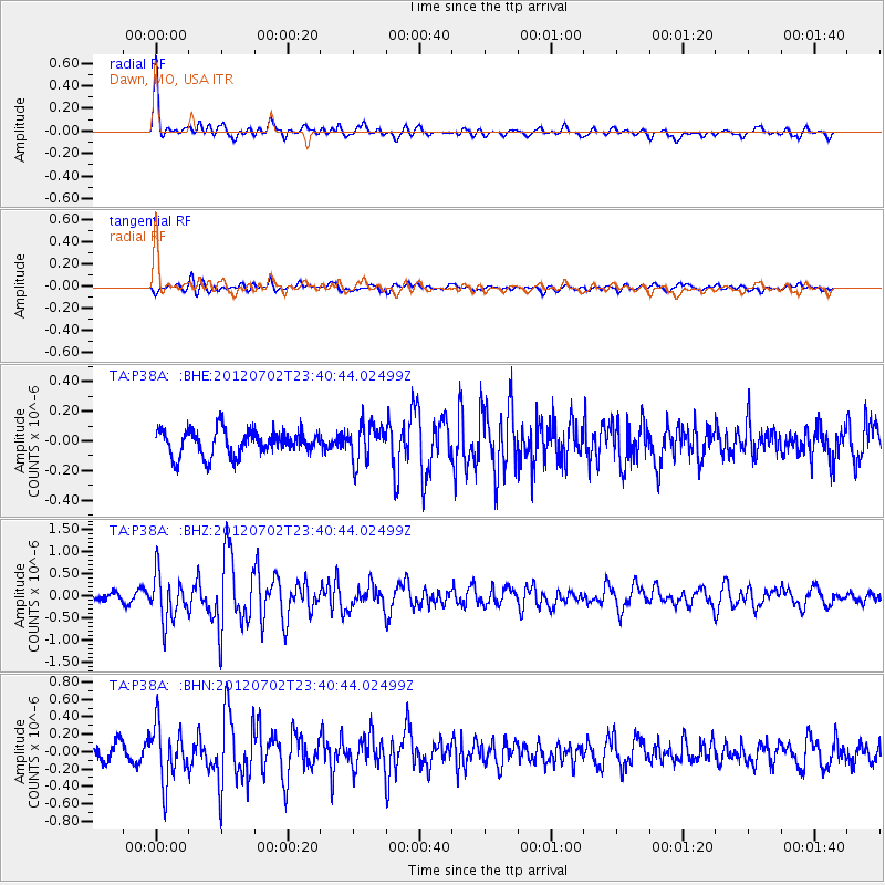
Signal To Noise
| Channel | StoN | STA | LTA |
| TA:P38A: :BHZ:20120702T23:40:44.02499Z | 7.614116 | 5.1907585E-7 | 6.817283E-8 |
| TA:P38A: :BHN:20120702T23:40:44.02499Z | 4.1572523 | 3.1661355E-7 | 7.615934E-8 |
| TA:P38A: :BHE:20120702T23:40:44.02499Z | 1.4317573 | 1.2076394E-7 | 8.434666E-8 |
| Arrivals |
| Ps | 6.6 SECOND |
| PpPs | 23 SECOND |
| PsPs/PpSs | 29 SECOND |


