You are here: Home > Network List > TA - USArray Transportable Network (new EarthScope stations) Stations List
> Station Q39A Willow Grove Farm, Nelson, MO, USA > Earthquake Result Viewer
Q39A Willow Grove Farm, Nelson, MO, USA - Earthquake Result Viewer
| Earthquake location: |
Near Coast Of Peru |
| Earthquake latitude/longitude: |
-14.4/-75.6 |
| Earthquake time(UTC): |
2012/07/02 (184) 23:31:37 GMT |
| Earthquake Depth: |
40 km |
| Earthquake Magnitude: |
6.0 MB, 5.2 MS, 5.7 MW, 5.6 MW |
| Earthquake Catalog/Contributor: |
WHDF/NEIC |
|
| Network: |
TA USArray Transportable Network (new EarthScope stations) |
| Station: |
Q39A Willow Grove Farm, Nelson, MO, USA |
| Lat/Lon: |
39.05 N/92.98 W |
| Elevation: |
225 m |
|
| Distance: |
55.6 deg |
| Az: |
343.631 deg |
| Baz: |
159.473 deg |
| Ray Param: |
0.06459641 |
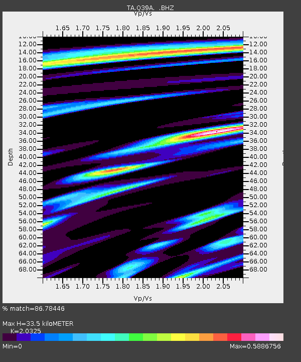
| Estimated Moho Depth: |
33.5 km |
| Estimated Crust Vp/Vs: |
2.03 |
| Assumed Crust Vp: |
6.498 km/s |
| Estimated Crust Vs: |
3.197 km/s |
| Estimated Crust Poisson's Ratio: |
0.34 |
|
| Radial Match: |
86.78446 % |
| Radial Bump: |
360 |
| Transverse Match: |
58.896038 % |
| Transverse Bump: |
400 |
| SOD ConfigId: |
463687 |
| Insert Time: |
2013-02-20 18:08:56.316 +0000 |
| GWidth: |
2.5 |
| Max Bumps: |
400 |
| Tol: |
0.001 |
|
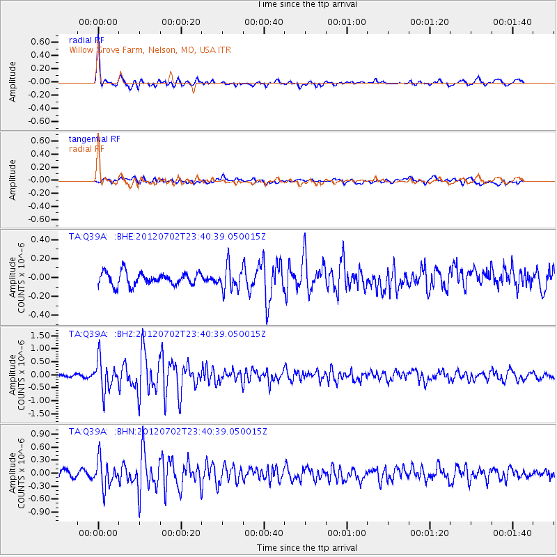
Signal To Noise
| Channel | StoN | STA | LTA |
| TA:Q39A: :BHZ:20120702T23:40:39.050015Z | 7.2676435 | 6.096426E-7 | 8.3884494E-8 |
| TA:Q39A: :BHN:20120702T23:40:39.050015Z | 4.3961782 | 3.242424E-7 | 7.3755515E-8 |
| TA:Q39A: :BHE:20120702T23:40:39.050015Z | 1.9063518 | 1.2771645E-7 | 6.699521E-8 |
| Arrivals |
| Ps | 5.6 SECOND |
| PpPs | 15 SECOND |
| PsPs/PpSs | 21 SECOND |


