You are here: Home > Network List > TA - USArray Transportable Network (new EarthScope stations) Stations List
> Station T38A Diamond, MO, USA > Earthquake Result Viewer
T38A Diamond, MO, USA - Earthquake Result Viewer
| Earthquake location: |
Near Coast Of Peru |
| Earthquake latitude/longitude: |
-14.4/-75.6 |
| Earthquake time(UTC): |
2012/07/02 (184) 23:31:37 GMT |
| Earthquake Depth: |
40 km |
| Earthquake Magnitude: |
6.0 MB, 5.2 MS, 5.7 MW, 5.6 MW |
| Earthquake Catalog/Contributor: |
WHDF/NEIC |
|
| Network: |
TA USArray Transportable Network (new EarthScope stations) |
| Station: |
T38A Diamond, MO, USA |
| Lat/Lon: |
37.04 N/94.29 W |
| Elevation: |
349 m |
|
| Distance: |
54.1 deg |
| Az: |
341.547 deg |
| Baz: |
157.465 deg |
| Ray Param: |
0.065560736 |
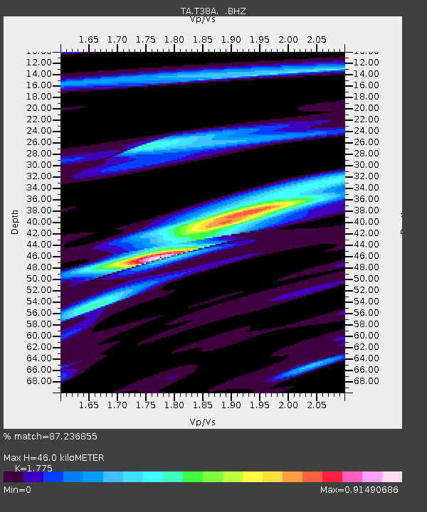
| Estimated Moho Depth: |
46.0 km |
| Estimated Crust Vp/Vs: |
1.77 |
| Assumed Crust Vp: |
6.53 km/s |
| Estimated Crust Vs: |
3.679 km/s |
| Estimated Crust Poisson's Ratio: |
0.27 |
|
| Radial Match: |
87.236855 % |
| Radial Bump: |
339 |
| Transverse Match: |
71.39282 % |
| Transverse Bump: |
400 |
| SOD ConfigId: |
463687 |
| Insert Time: |
2013-02-20 18:10:15.756 +0000 |
| GWidth: |
2.5 |
| Max Bumps: |
400 |
| Tol: |
0.001 |
|

Signal To Noise
| Channel | StoN | STA | LTA |
| TA:T38A: :BHZ:20120702T23:40:28.350002Z | 14.984198 | 7.072657E-7 | 4.720077E-8 |
| TA:T38A: :BHN:20120702T23:40:28.350002Z | 6.441971 | 3.307756E-7 | 5.1346962E-8 |
| TA:T38A: :BHE:20120702T23:40:28.350002Z | 3.1629095 | 1.9886781E-7 | 6.287496E-8 |
| Arrivals |
| Ps | 5.8 SECOND |
| PpPs | 18 SECOND |
| PsPs/PpSs | 24 SECOND |


