You are here: Home > Network List > TA - USArray Transportable Network (new EarthScope stations) Stations List
> Station Y42A Garnett, Star City, AR, USA > Earthquake Result Viewer
Y42A Garnett, Star City, AR, USA - Earthquake Result Viewer
| Earthquake location: |
Near Coast Of Peru |
| Earthquake latitude/longitude: |
-14.4/-75.6 |
| Earthquake time(UTC): |
2012/07/02 (184) 23:31:37 GMT |
| Earthquake Depth: |
40 km |
| Earthquake Magnitude: |
6.0 MB, 5.2 MS, 5.7 MW, 5.6 MW |
| Earthquake Catalog/Contributor: |
WHDF/NEIC |
|
| Network: |
TA USArray Transportable Network (new EarthScope stations) |
| Station: |
Y42A Garnett, Star City, AR, USA |
| Lat/Lon: |
33.84 N/91.79 W |
| Elevation: |
77 m |
|
| Distance: |
50.4 deg |
| Az: |
342.474 deg |
| Baz: |
159.48 deg |
| Ray Param: |
0.067986295 |
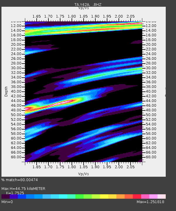
| Estimated Moho Depth: |
44.75 km |
| Estimated Crust Vp/Vs: |
1.75 |
| Assumed Crust Vp: |
6.201 km/s |
| Estimated Crust Vs: |
3.539 km/s |
| Estimated Crust Poisson's Ratio: |
0.26 |
|
| Radial Match: |
80.00474 % |
| Radial Bump: |
400 |
| Transverse Match: |
73.07612 % |
| Transverse Bump: |
400 |
| SOD ConfigId: |
463687 |
| Insert Time: |
2013-02-20 18:14:14.301 +0000 |
| GWidth: |
2.5 |
| Max Bumps: |
400 |
| Tol: |
0.001 |
|
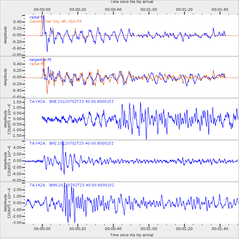
Signal To Noise
| Channel | StoN | STA | LTA |
| TA:Y42A: :BHZ:20120702T23:40:00.800015Z | 8.814861 | 1.0132301E-6 | 1.1494567E-7 |
| TA:Y42A: :BHN:20120702T23:40:00.800015Z | 1.396406 | 5.574981E-7 | 3.992378E-7 |
| TA:Y42A: :BHE:20120702T23:40:00.800015Z | 2.252039 | 4.097032E-7 | 1.8192546E-7 |
| Arrivals |
| Ps | 5.7 SECOND |
| PpPs | 19 SECOND |
| PsPs/PpSs | 25 SECOND |


