You are here: Home > Network List > G - GEOSCOPE Stations List
> Station SSB Saint Sauveur Badole, France > Earthquake Result Viewer
SSB Saint Sauveur Badole, France - Earthquake Result Viewer
| Earthquake location: |
Near West Coast Of Colombia |
| Earthquake latitude/longitude: |
3.0/-78.0 |
| Earthquake time(UTC): |
2007/09/10 (253) 01:49:14 GMT |
| Earthquake Depth: |
31 km |
| Earthquake Magnitude: |
6.1 MB, 6.7 MS, 6.8 MW |
| Earthquake Catalog/Contributor: |
WHDF/NEIC |
|
| Network: |
G GEOSCOPE |
| Station: |
SSB Saint Sauveur Badole, France |
| Lat/Lon: |
45.28 N/4.54 E |
| Elevation: |
700 m |
|
| Distance: |
82.6 deg |
| Az: |
44.899 deg |
| Baz: |
266.779 deg |
| Ray Param: |
0.046723913 |
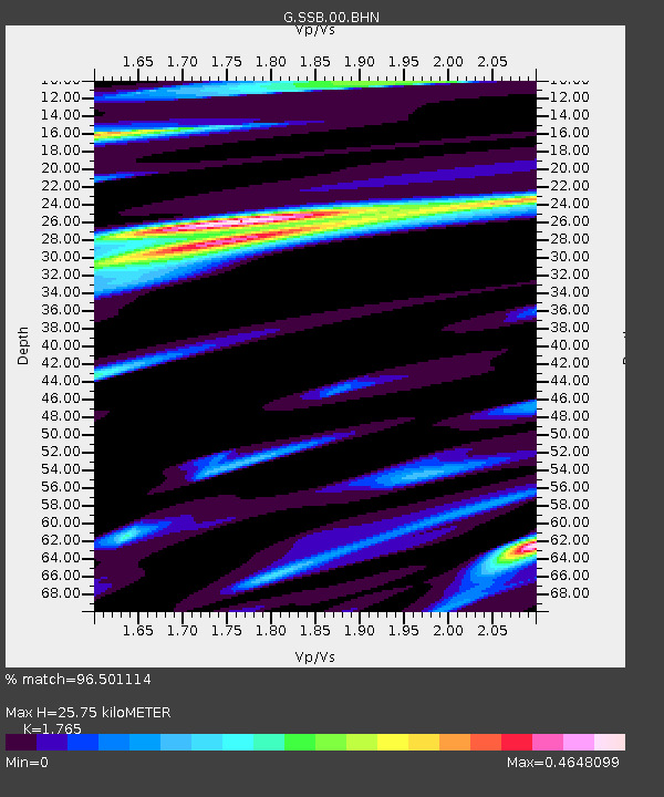
| Estimated Moho Depth: |
25.75 km |
| Estimated Crust Vp/Vs: |
1.76 |
| Assumed Crust Vp: |
6.1 km/s |
| Estimated Crust Vs: |
3.456 km/s |
| Estimated Crust Poisson's Ratio: |
0.26 |
|
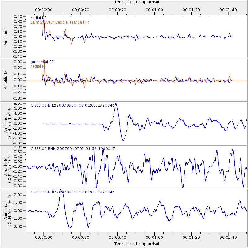
| Radial Match: |
96.501114 % |
| Radial Bump: |
343 |
| Transverse Match: |
87.11719 % |
| Transverse Bump: |
400 |
| SOD ConfigId: |
2564 |
| Insert Time: |
2010-02-27 00:11:30.984 +0000 |
| GWidth: |
2.5 |
| Max Bumps: |
400 |
| Tol: |
0.001 |
|
Signal To Noise
| Channel | StoN | STA | LTA |
| G:SSB:00:BHN:20070910T02:01:03.199004Z | 2.0030525 | 6.360833E-8 | 3.1755697E-8 |
| G:SSB:00:BHE:20070910T02:01:03.199004Z | 9.1814785 | 4.0074042E-7 | 4.3646608E-8 |
| G:SSB:00:BHZ:20070910T02:01:03.199004Z | 21.955412 | 1.2553245E-6 | 5.7176084E-8 |
| Arrivals |
| Ps | 3.3 SECOND |
| PpPs | 11 SECOND |
| PsPs/PpSs | 15 SECOND |


