You are here: Home > Network List > TA - USArray Transportable Network (new EarthScope stations) Stations List
> Station T41A Mountain View, MO, USA > Earthquake Result Viewer
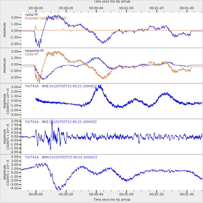
T41A Mountain View, MO, USA - Earthquake Result Viewer
*The percent match for this event was below the threshold and hence no stack was calculated.
| Earthquake location: |
Near Coast Of Peru |
| Earthquake latitude/longitude: |
-14.4/-75.6 |
| Earthquake time(UTC): |
2012/07/02 (184) 23:31:37 GMT |
| Earthquake Depth: |
40 km |
| Earthquake Magnitude: |
6.0 MB, 5.2 MS, 5.7 MW, 5.6 MW |
| Earthquake Catalog/Contributor: |
WHDF/NEIC |
|
| Network: |
TA USArray Transportable Network (new EarthScope stations) |
| Station: |
T41A Mountain View, MO, USA |
| Lat/Lon: |
37.04 N/91.76 W |
| Elevation: |
366 m |
|
| Distance: |
53.4 deg |
| Az: |
343.892 deg |
| Baz: |
160.369 deg |
| Ray Param: |
$rayparam |
*The percent match for this event was below the threshold and hence was not used in the summary stack. |
|
| Radial Match: |
48.100624 % |
| Radial Bump: |
400 |
| Transverse Match: |
83.30848 % |
| Transverse Bump: |
400 |
| SOD ConfigId: |
463687 |
| Insert Time: |
2013-02-20 18:15:43.929 +0000 |
| GWidth: |
2.5 |
| Max Bumps: |
400 |
| Tol: |
0.001 |
|
Signal To Noise
| Channel | StoN | STA | LTA |
| TA:T41A: :BHZ:20120702T23:40:23.100002Z | 7.9688625 | 4.907663E-7 | 6.158549E-8 |
| TA:T41A: :BHN:20120702T23:40:23.100002Z | 1.5096426 | 2.521346E-6 | 1.6701608E-6 |
| TA:T41A: :BHE:20120702T23:40:23.100002Z | 2.0247014 | 5.4978074E-7 | 2.715367E-7 |
| Arrivals |
| Ps | |
| PpPs | |
| PsPs/PpSs | |


