You are here: Home > Network List > TA - USArray Transportable Network (new EarthScope stations) Stations List
> Station V42A Cord, AR, USA > Earthquake Result Viewer
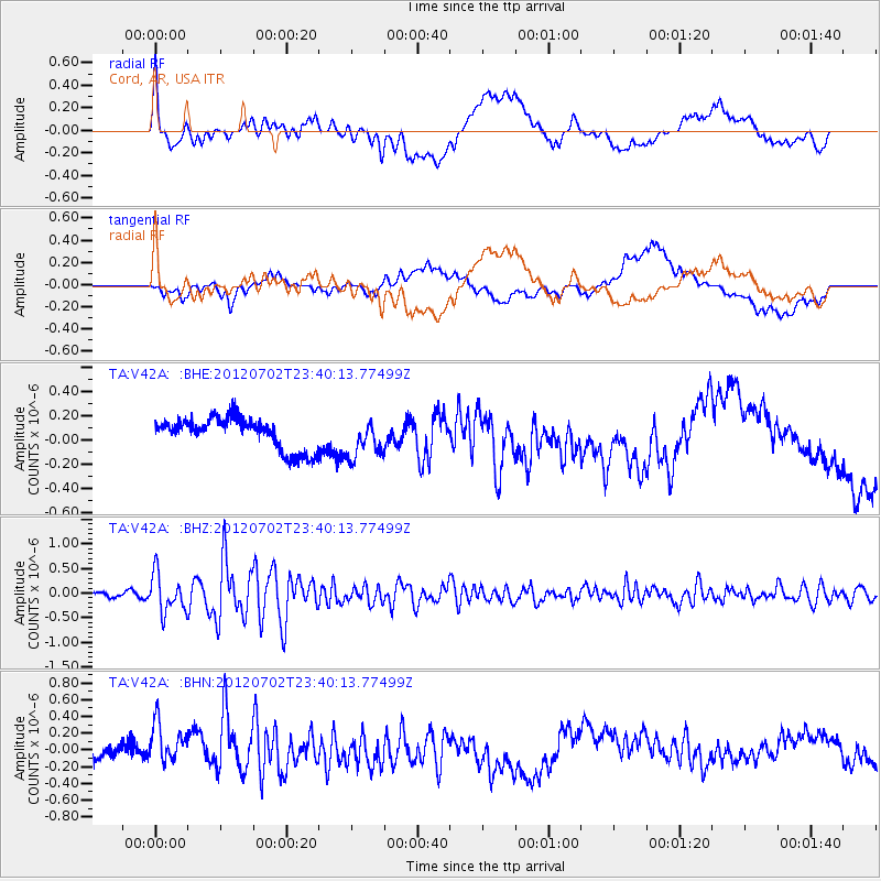
V42A Cord, AR, USA - Earthquake Result Viewer
*The percent match for this event was below the threshold and hence no stack was calculated.
| Earthquake location: |
Near Coast Of Peru |
| Earthquake latitude/longitude: |
-14.4/-75.6 |
| Earthquake time(UTC): |
2012/07/02 (184) 23:31:37 GMT |
| Earthquake Depth: |
40 km |
| Earthquake Magnitude: |
6.0 MB, 5.2 MS, 5.7 MW, 5.6 MW |
| Earthquake Catalog/Contributor: |
WHDF/NEIC |
|
| Network: |
TA USArray Transportable Network (new EarthScope stations) |
| Station: |
V42A Cord, AR, USA |
| Lat/Lon: |
35.81 N/91.39 W |
| Elevation: |
134 m |
|
| Distance: |
52.1 deg |
| Az: |
343.729 deg |
| Baz: |
160.491 deg |
| Ray Param: |
$rayparam |
*The percent match for this event was below the threshold and hence was not used in the summary stack. |
|
| Radial Match: |
60.414604 % |
| Radial Bump: |
400 |
| Transverse Match: |
36.638496 % |
| Transverse Bump: |
400 |
| SOD ConfigId: |
463687 |
| Insert Time: |
2013-02-20 18:16:08.202 +0000 |
| GWidth: |
2.5 |
| Max Bumps: |
400 |
| Tol: |
0.001 |
|
Signal To Noise
| Channel | StoN | STA | LTA |
| TA:V42A: :BHZ:20120702T23:40:13.77499Z | 7.528178 | 3.8303725E-7 | 5.0880473E-8 |
| TA:V42A: :BHN:20120702T23:40:13.77499Z | 2.0381756 | 2.7768945E-7 | 1.3624413E-7 |
| TA:V42A: :BHE:20120702T23:40:13.77499Z | 1.2011441 | 1.5790378E-7 | 1.3146114E-7 |
| Arrivals |
| Ps | |
| PpPs | |
| PsPs/PpSs | |


