You are here: Home > Network List > TA - USArray Transportable Network (new EarthScope stations) Stations List
> Station V45A Humboldt, TN, USA > Earthquake Result Viewer
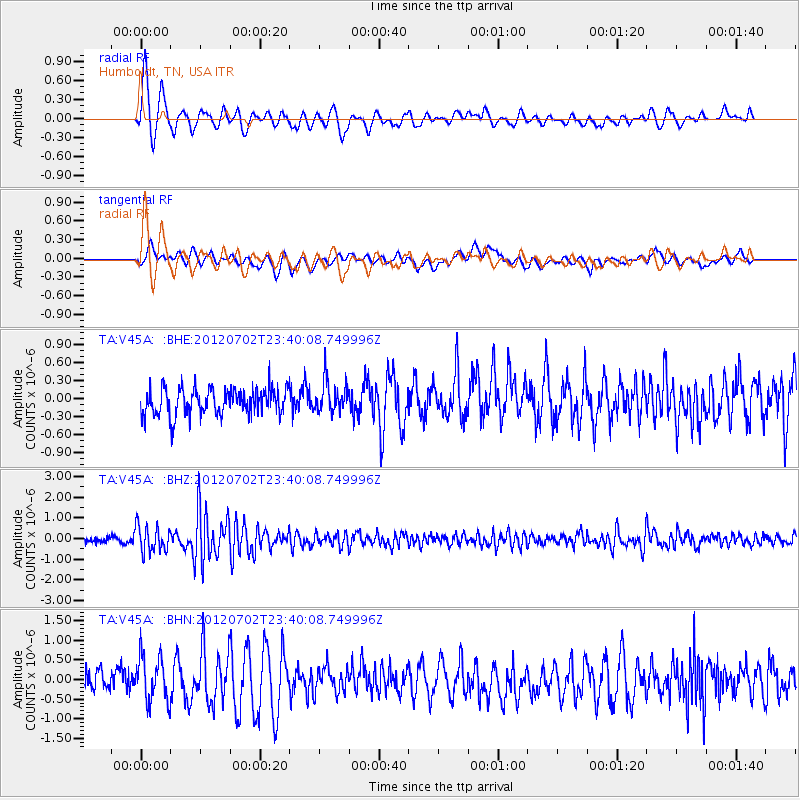
V45A Humboldt, TN, USA - Earthquake Result Viewer
*The percent match for this event was below the threshold and hence no stack was calculated.
| Earthquake location: |
Near Coast Of Peru |
| Earthquake latitude/longitude: |
-14.4/-75.6 |
| Earthquake time(UTC): |
2012/07/02 (184) 23:31:37 GMT |
| Earthquake Depth: |
40 km |
| Earthquake Magnitude: |
6.0 MB, 5.2 MS, 5.7 MW, 5.6 MW |
| Earthquake Catalog/Contributor: |
WHDF/NEIC |
|
| Network: |
TA USArray Transportable Network (new EarthScope stations) |
| Station: |
V45A Humboldt, TN, USA |
| Lat/Lon: |
35.74 N/88.96 W |
| Elevation: |
126 m |
|
| Distance: |
51.5 deg |
| Az: |
346.094 deg |
| Baz: |
163.368 deg |
| Ray Param: |
$rayparam |
*The percent match for this event was below the threshold and hence was not used in the summary stack. |
|
| Radial Match: |
79.552536 % |
| Radial Bump: |
400 |
| Transverse Match: |
63.302967 % |
| Transverse Bump: |
400 |
| SOD ConfigId: |
463687 |
| Insert Time: |
2013-02-20 18:16:20.176 +0000 |
| GWidth: |
2.5 |
| Max Bumps: |
400 |
| Tol: |
0.001 |
|
Signal To Noise
| Channel | StoN | STA | LTA |
| TA:V45A: :BHZ:20120702T23:40:08.749996Z | 5.3124666 | 6.371783E-7 | 1.199402E-7 |
| TA:V45A: :BHN:20120702T23:40:08.749996Z | 2.3267574 | 5.890713E-7 | 2.5317263E-7 |
| TA:V45A: :BHE:20120702T23:40:08.749996Z | 1.1765788 | 2.5722466E-7 | 2.1862085E-7 |
| Arrivals |
| Ps | |
| PpPs | |
| PsPs/PpSs | |


