You are here: Home > Network List > TA - USArray Transportable Network (new EarthScope stations) Stations List
> Station S45A Carrier Mills, IL, USA > Earthquake Result Viewer
S45A Carrier Mills, IL, USA - Earthquake Result Viewer
| Earthquake location: |
Near Coast Of Peru |
| Earthquake latitude/longitude: |
-14.4/-75.6 |
| Earthquake time(UTC): |
2012/07/02 (184) 23:31:37 GMT |
| Earthquake Depth: |
40 km |
| Earthquake Magnitude: |
6.0 MB, 5.2 MS, 5.7 MW, 5.6 MW |
| Earthquake Catalog/Contributor: |
WHDF/NEIC |
|
| Network: |
TA USArray Transportable Network (new EarthScope stations) |
| Station: |
S45A Carrier Mills, IL, USA |
| Lat/Lon: |
37.68 N/88.58 W |
| Elevation: |
122 m |
|
| Distance: |
53.2 deg |
| Az: |
347.145 deg |
| Baz: |
164.235 deg |
| Ray Param: |
0.06614579 |
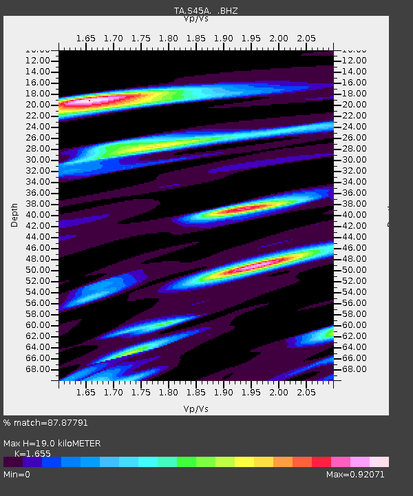
| Estimated Moho Depth: |
19.0 km |
| Estimated Crust Vp/Vs: |
1.65 |
| Assumed Crust Vp: |
6.444 km/s |
| Estimated Crust Vs: |
3.894 km/s |
| Estimated Crust Poisson's Ratio: |
0.21 |
|
| Radial Match: |
87.87791 % |
| Radial Bump: |
379 |
| Transverse Match: |
69.41351 % |
| Transverse Bump: |
400 |
| SOD ConfigId: |
463687 |
| Insert Time: |
2013-02-20 18:16:44.540 +0000 |
| GWidth: |
2.5 |
| Max Bumps: |
400 |
| Tol: |
0.001 |
|

Signal To Noise
| Channel | StoN | STA | LTA |
| TA:S45A: :BHZ:20120702T23:40:21.850002Z | 5.1415615 | 4.5010356E-7 | 8.754219E-8 |
| TA:S45A: :BHN:20120702T23:40:21.850002Z | 4.1021686 | 3.1392733E-7 | 7.6527165E-8 |
| TA:S45A: :BHE:20120702T23:40:21.850002Z | 1.2767498 | 8.853686E-8 | 6.93455E-8 |
| Arrivals |
| Ps | 2.0 SECOND |
| PpPs | 7.4 SECOND |
| PsPs/PpSs | 9.4 SECOND |


