SSB Saint Sauveur Badole, France - Earthquake Result Viewer
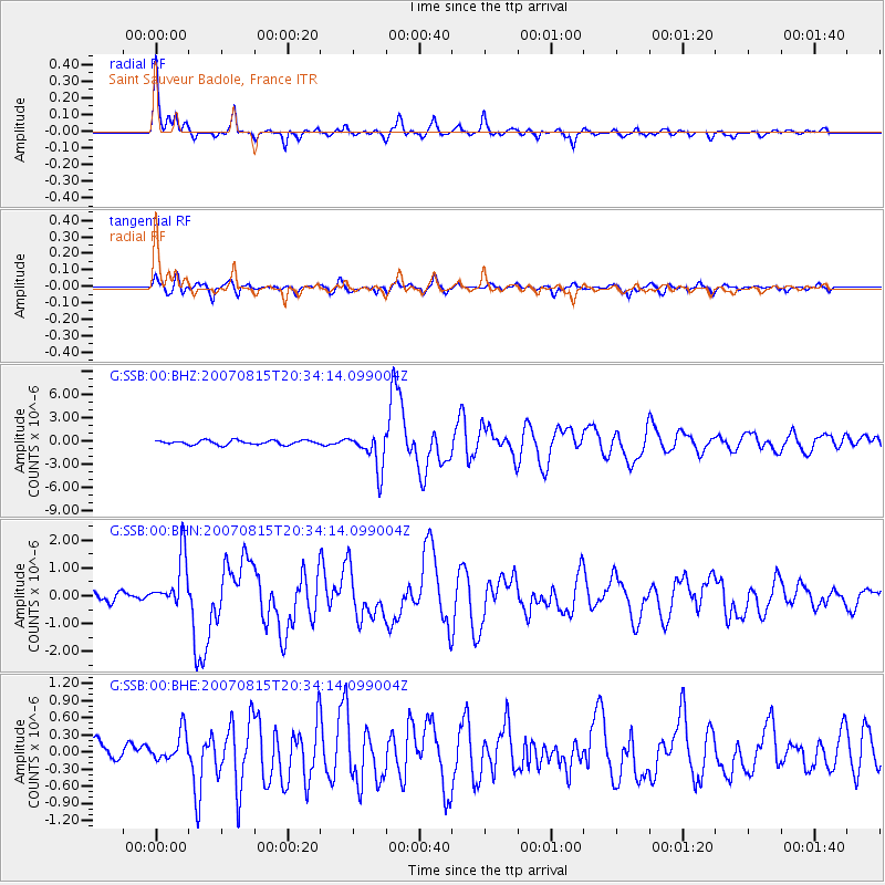
Earthquake location: Andreanof Islands, Aleutian Is.
Earthquake latitude/longitude: 50.3/-177.5
Earthquake time(UTC): 2007/08/15 (227) 20:22:11 GMT
Earthquake Depth: 9.0 km
Earthquake Magnitude: 6.3 MB, 6.2 MS, 6.4 MW, 5.9 ML
Earthquake Catalog/Contributor: WHDF/NEIC
Network: G GEOSCOPE
Station: SSB Saint Sauveur Badole, France
Lat/Lon: 45.28 N/4.54 E
Elevation: 700 m
Distance: 84.8 deg
Az: 358.518 deg
Baz: 1.345 deg
Ray Param: 0.04525104
Estimated Moho Depth: 28.25 km
Estimated Crust Vp/Vs: 1.66
Assumed Crust Vp: 6.1 km/s
Estimated Crust Vs: 3.675 km/s
Estimated Crust Poisson's Ratio: 0.22
Radial Match: 93.083916 %
Radial Bump: 363
Transverse Match: 80.64798 %
Transverse Bump: 400
SOD ConfigId: 2564
Insert Time: 2010-02-27 00:11:37.119 +0000
GWidth: 2.5
Max Bumps: 400
Tol: 0.001

Signal To Noise

ChannelStoNSTALTA
G:SSB:00:BHN:20070815T20:34:14.099004Z4.1049028.920439E-72.1731188E-7
G:SSB:00:BHE:20070815T20:34:14.099004Z1.56991352.5983812E-71.655111E-7
G:SSB:00:BHZ:20070815T20:34:14.099004Z8.71334652.4147635E-62.771339E-7
Arrivals
Ps3.1 SECOND
PpPs12 SECOND
PsPs/PpSs15 SECOND