You are here: Home > Network List > TA - USArray Transportable Network (new EarthScope stations) Stations List
> Station P42A Winchester, IL, USA > Earthquake Result Viewer
P42A Winchester, IL, USA - Earthquake Result Viewer
| Earthquake location: |
Near Coast Of Peru |
| Earthquake latitude/longitude: |
-14.4/-75.6 |
| Earthquake time(UTC): |
2012/07/02 (184) 23:31:37 GMT |
| Earthquake Depth: |
40 km |
| Earthquake Magnitude: |
6.0 MB, 5.2 MS, 5.7 MW, 5.6 MW |
| Earthquake Catalog/Contributor: |
WHDF/NEIC |
|
| Network: |
TA USArray Transportable Network (new EarthScope stations) |
| Station: |
P42A Winchester, IL, USA |
| Lat/Lon: |
39.59 N/90.34 W |
| Elevation: |
197 m |
|
| Distance: |
55.5 deg |
| Az: |
346.185 deg |
| Baz: |
162.579 deg |
| Ray Param: |
0.0646966 |
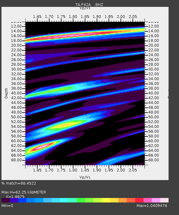
| Estimated Moho Depth: |
62.25 km |
| Estimated Crust Vp/Vs: |
1.67 |
| Assumed Crust Vp: |
6.498 km/s |
| Estimated Crust Vs: |
3.897 km/s |
| Estimated Crust Poisson's Ratio: |
0.22 |
|
| Radial Match: |
86.4522 % |
| Radial Bump: |
387 |
| Transverse Match: |
62.55515 % |
| Transverse Bump: |
400 |
| SOD ConfigId: |
463687 |
| Insert Time: |
2013-02-20 18:18:27.237 +0000 |
| GWidth: |
2.5 |
| Max Bumps: |
400 |
| Tol: |
0.001 |
|

Signal To Noise
| Channel | StoN | STA | LTA |
| TA:P42A: :BHZ:20120702T23:40:37.949978Z | 5.835567 | 4.442254E-7 | 7.6123776E-8 |
| TA:P42A: :BHN:20120702T23:40:37.949978Z | 2.719964 | 2.758889E-7 | 1.01431084E-7 |
| TA:P42A: :BHE:20120702T23:40:37.949978Z | 1.8859272 | 1.7545078E-7 | 9.3031574E-8 |
| Arrivals |
| Ps | 6.8 SECOND |
| PpPs | 24 SECOND |
| PsPs/PpSs | 31 SECOND |


