You are here: Home > Network List > TA - USArray Transportable Network (new EarthScope stations) Stations List
> Station S42A Caledonia, MO, USA > Earthquake Result Viewer
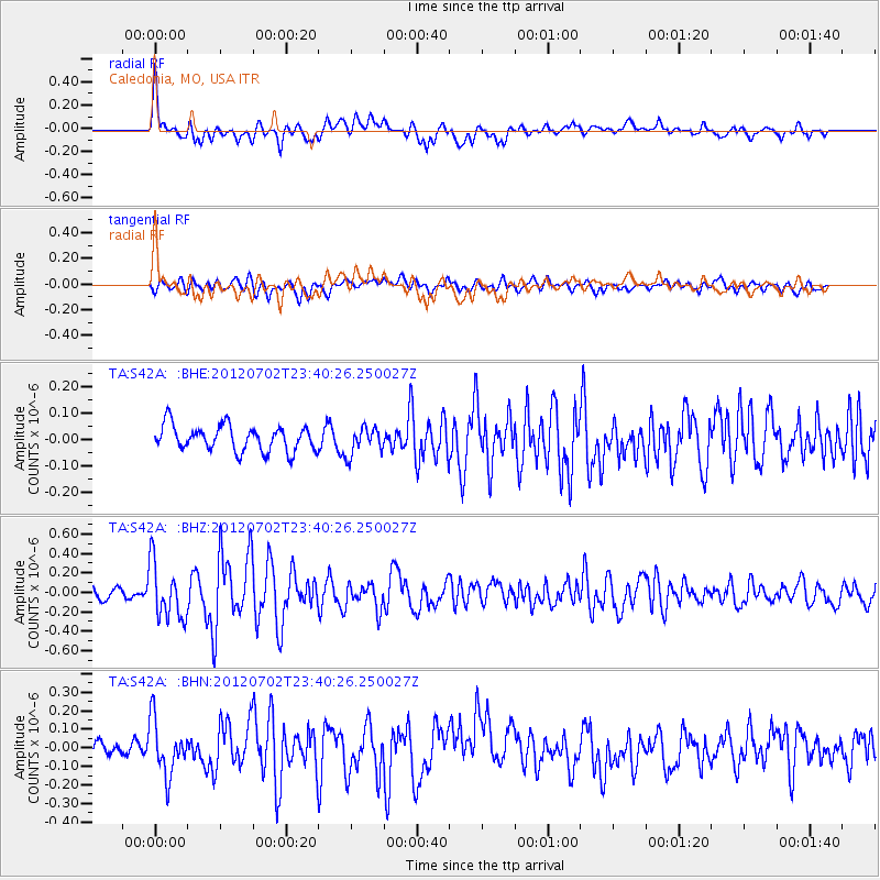
S42A Caledonia, MO, USA - Earthquake Result Viewer
*The percent match for this event was below the threshold and hence no stack was calculated.
| Earthquake location: |
Near Coast Of Peru |
| Earthquake latitude/longitude: |
-14.4/-75.6 |
| Earthquake time(UTC): |
2012/07/02 (184) 23:31:37 GMT |
| Earthquake Depth: |
40 km |
| Earthquake Magnitude: |
6.0 MB, 5.2 MS, 5.7 MW, 5.6 MW |
| Earthquake Catalog/Contributor: |
WHDF/NEIC |
|
| Network: |
TA USArray Transportable Network (new EarthScope stations) |
| Station: |
S42A Caledonia, MO, USA |
| Lat/Lon: |
37.77 N/90.79 W |
| Elevation: |
315 m |
|
| Distance: |
53.8 deg |
| Az: |
345.092 deg |
| Baz: |
161.667 deg |
| Ray Param: |
$rayparam |
*The percent match for this event was below the threshold and hence was not used in the summary stack. |
|
| Radial Match: |
74.71509 % |
| Radial Bump: |
400 |
| Transverse Match: |
56.306103 % |
| Transverse Bump: |
400 |
| SOD ConfigId: |
463687 |
| Insert Time: |
2013-02-20 18:19:17.344 +0000 |
| GWidth: |
2.5 |
| Max Bumps: |
400 |
| Tol: |
0.001 |
|
Signal To Noise
| Channel | StoN | STA | LTA |
| TA:S42A: :BHZ:20120702T23:40:26.250027Z | 5.7492194 | 2.8730267E-7 | 4.9972464E-8 |
| TA:S42A: :BHN:20120702T23:40:26.250027Z | 2.6881475 | 1.463757E-7 | 5.4452258E-8 |
| TA:S42A: :BHE:20120702T23:40:26.250027Z | 1.0768085 | 5.161943E-8 | 4.7937434E-8 |
| Arrivals |
| Ps | |
| PpPs | |
| PsPs/PpSs | |


