You are here: Home > Network List > TA - USArray Transportable Network (new EarthScope stations) Stations List
> Station M42A Sheffield, IL, USA > Earthquake Result Viewer
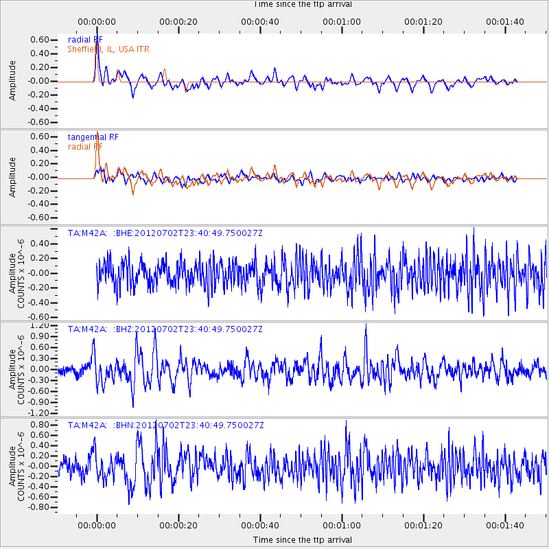
M42A Sheffield, IL, USA - Earthquake Result Viewer
*The percent match for this event was below the threshold and hence no stack was calculated.
| Earthquake location: |
Near Coast Of Peru |
| Earthquake latitude/longitude: |
-14.4/-75.6 |
| Earthquake time(UTC): |
2012/07/02 (184) 23:31:37 GMT |
| Earthquake Depth: |
40 km |
| Earthquake Magnitude: |
6.0 MB, 5.2 MS, 5.7 MW, 5.6 MW |
| Earthquake Catalog/Contributor: |
WHDF/NEIC |
|
| Network: |
TA USArray Transportable Network (new EarthScope stations) |
| Station: |
M42A Sheffield, IL, USA |
| Lat/Lon: |
41.45 N/89.76 W |
| Elevation: |
212 m |
|
| Distance: |
57.1 deg |
| Az: |
347.352 deg |
| Baz: |
163.606 deg |
| Ray Param: |
$rayparam |
*The percent match for this event was below the threshold and hence was not used in the summary stack. |
|
| Radial Match: |
73.27684 % |
| Radial Bump: |
400 |
| Transverse Match: |
58.000492 % |
| Transverse Bump: |
400 |
| SOD ConfigId: |
463687 |
| Insert Time: |
2013-02-20 18:19:52.686 +0000 |
| GWidth: |
2.5 |
| Max Bumps: |
400 |
| Tol: |
0.001 |
|
Signal To Noise
| Channel | StoN | STA | LTA |
| TA:M42A: :BHZ:20120702T23:40:49.750027Z | 4.0926437 | 3.69478E-7 | 9.027856E-8 |
| TA:M42A: :BHN:20120702T23:40:49.750027Z | 1.6087861 | 2.4469497E-7 | 1.5209913E-7 |
| TA:M42A: :BHE:20120702T23:40:49.750027Z | 0.9396624 | 1.3636993E-7 | 1.4512652E-7 |
| Arrivals |
| Ps | |
| PpPs | |
| PsPs/PpSs | |


