You are here: Home > Network List > TA - USArray Transportable Network (new EarthScope stations) Stations List
> Station E39A Mellen, WI, USA > Earthquake Result Viewer
E39A Mellen, WI, USA - Earthquake Result Viewer
| Earthquake location: |
Near Coast Of Peru |
| Earthquake latitude/longitude: |
-14.4/-75.6 |
| Earthquake time(UTC): |
2012/07/02 (184) 23:31:37 GMT |
| Earthquake Depth: |
40 km |
| Earthquake Magnitude: |
6.0 MB, 5.2 MS, 5.7 MW, 5.6 MW |
| Earthquake Catalog/Contributor: |
WHDF/NEIC |
|
| Network: |
TA USArray Transportable Network (new EarthScope stations) |
| Station: |
E39A Mellen, WI, USA |
| Lat/Lon: |
46.38 N/90.56 W |
| Elevation: |
426 m |
|
| Distance: |
62.0 deg |
| Az: |
348.324 deg |
| Baz: |
163.547 deg |
| Ray Param: |
0.06043879 |
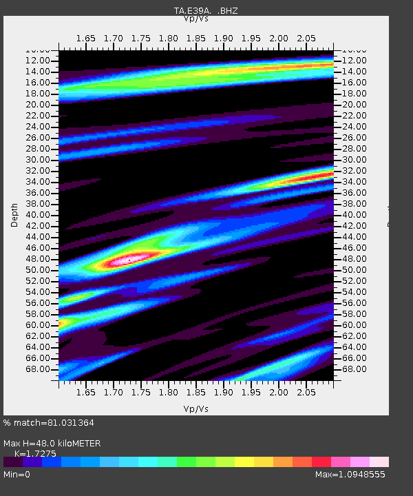
| Estimated Moho Depth: |
48.0 km |
| Estimated Crust Vp/Vs: |
1.73 |
| Assumed Crust Vp: |
6.467 km/s |
| Estimated Crust Vs: |
3.743 km/s |
| Estimated Crust Poisson's Ratio: |
0.25 |
|
| Radial Match: |
81.031364 % |
| Radial Bump: |
400 |
| Transverse Match: |
62.16833 % |
| Transverse Bump: |
400 |
| SOD ConfigId: |
463687 |
| Insert Time: |
2013-02-20 18:22:47.859 +0000 |
| GWidth: |
2.5 |
| Max Bumps: |
400 |
| Tol: |
0.001 |
|
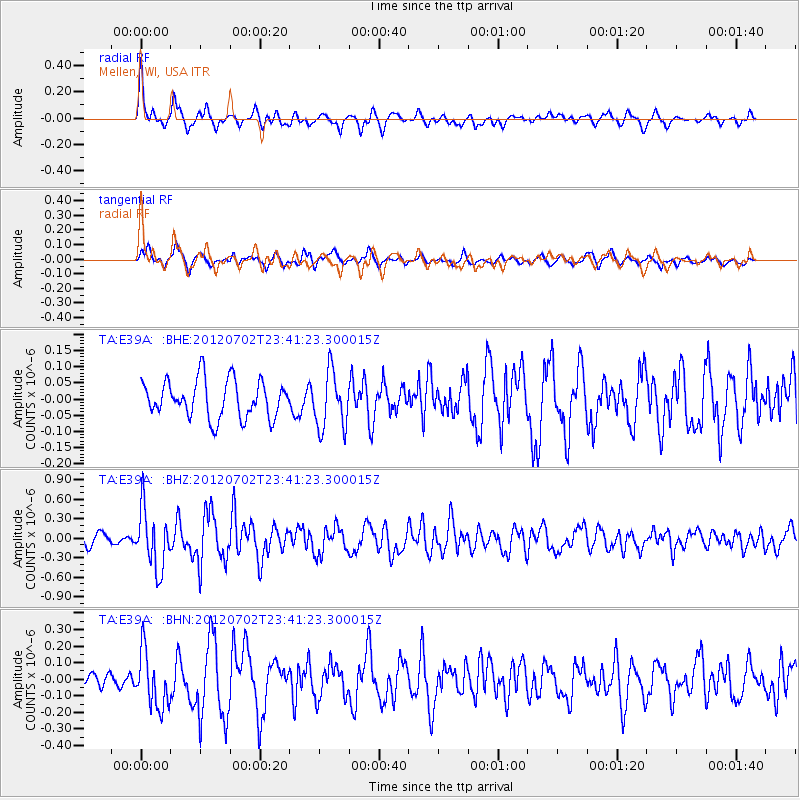
Signal To Noise
| Channel | StoN | STA | LTA |
| TA:E39A: :BHZ:20120702T23:41:23.300015Z | 6.061567 | 4.53553E-7 | 7.4824385E-8 |
| TA:E39A: :BHN:20120702T23:41:23.300015Z | 3.5648844 | 1.6957382E-7 | 4.756783E-8 |
| TA:E39A: :BHE:20120702T23:41:23.300015Z | 1.5287346 | 8.79032E-8 | 5.7500632E-8 |
| Arrivals |
| Ps | 5.7 SECOND |
| PpPs | 19 SECOND |
| PsPs/PpSs | 25 SECOND |


