You are here: Home > Network List > TA - USArray Transportable Network (new EarthScope stations) Stations List
> Station H17A Grant Village (NPS), Yellowstone Nt. Park, WY, USA > Earthquake Result Viewer
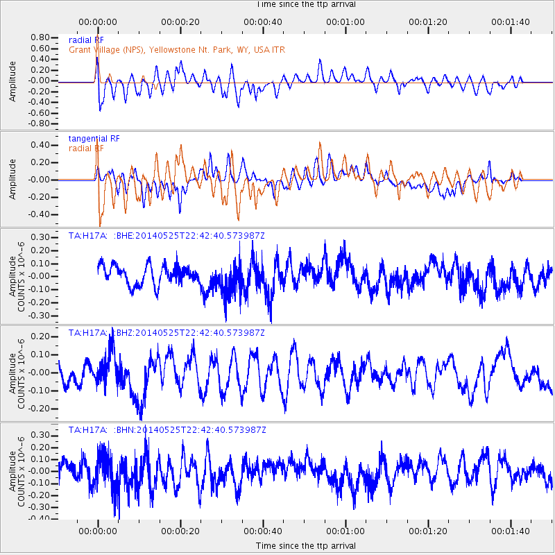
H17A Grant Village (NPS), Yellowstone Nt. Park, WY, USA - Earthquake Result Viewer
*The percent match for this event was below the threshold and hence no stack was calculated.
| Earthquake location: |
Near Coast Of Guatemala |
| Earthquake latitude/longitude: |
13.4/-90.9 |
| Earthquake time(UTC): |
2014/05/25 (145) 22:36:19 GMT |
| Earthquake Depth: |
30 km |
| Earthquake Magnitude: |
5.3 MW |
| Earthquake Catalog/Contributor: |
ISC/ISC |
|
| Network: |
TA USArray Transportable Network (new EarthScope stations) |
| Station: |
H17A Grant Village (NPS), Yellowstone Nt. Park, WY, USA |
| Lat/Lon: |
44.40 N/110.58 W |
| Elevation: |
2400 m |
|
| Distance: |
35.2 deg |
| Az: |
335.212 deg |
| Baz: |
145.311 deg |
| Ray Param: |
$rayparam |
*The percent match for this event was below the threshold and hence was not used in the summary stack. |
|
| Radial Match: |
57.099922 % |
| Radial Bump: |
400 |
| Transverse Match: |
53.99647 % |
| Transverse Bump: |
400 |
| SOD ConfigId: |
3390531 |
| Insert Time: |
2019-04-12 01:13:43.853 +0000 |
| GWidth: |
2.5 |
| Max Bumps: |
400 |
| Tol: |
0.001 |
|
Signal To Noise
| Channel | StoN | STA | LTA |
| TA:H17A: :BHZ:20140525T22:42:40.573987Z | 1.5876175 | 9.7453395E-8 | 6.1383425E-8 |
| TA:H17A: :BHN:20140525T22:42:40.573987Z | 2.0791295 | 1.4454847E-7 | 6.952355E-8 |
| TA:H17A: :BHE:20140525T22:42:40.573987Z | 1.8855349 | 1.3603663E-7 | 7.214751E-8 |
| Arrivals |
| Ps | |
| PpPs | |
| PsPs/PpSs | |


