You are here: Home > Network List > TA - USArray Transportable Network (new EarthScope stations) Stations List
> Station H43A Windswept, Luxemburg, WI, USA > Earthquake Result Viewer
H43A Windswept, Luxemburg, WI, USA - Earthquake Result Viewer
| Earthquake location: |
Near Coast Of Peru |
| Earthquake latitude/longitude: |
-14.4/-75.6 |
| Earthquake time(UTC): |
2012/07/02 (184) 23:31:37 GMT |
| Earthquake Depth: |
40 km |
| Earthquake Magnitude: |
6.0 MB, 5.2 MS, 5.7 MW, 5.6 MW |
| Earthquake Catalog/Contributor: |
WHDF/NEIC |
|
| Network: |
TA USArray Transportable Network (new EarthScope stations) |
| Station: |
H43A Windswept, Luxemburg, WI, USA |
| Lat/Lon: |
44.47 N/87.77 W |
| Elevation: |
274 m |
|
| Distance: |
59.6 deg |
| Az: |
349.925 deg |
| Baz: |
166.306 deg |
| Ray Param: |
0.061971363 |
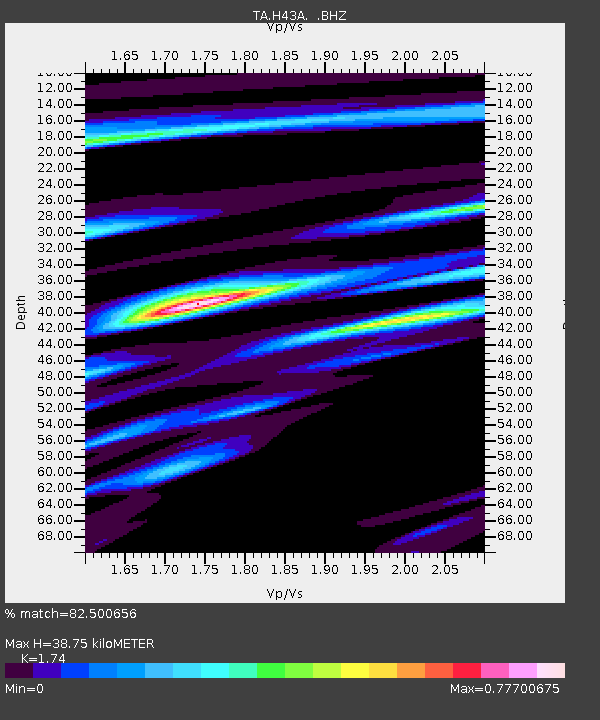
| Estimated Moho Depth: |
38.75 km |
| Estimated Crust Vp/Vs: |
1.74 |
| Assumed Crust Vp: |
6.53 km/s |
| Estimated Crust Vs: |
3.753 km/s |
| Estimated Crust Poisson's Ratio: |
0.25 |
|
| Radial Match: |
82.500656 % |
| Radial Bump: |
375 |
| Transverse Match: |
64.678474 % |
| Transverse Bump: |
400 |
| SOD ConfigId: |
463687 |
| Insert Time: |
2013-02-20 18:24:05.388 +0000 |
| GWidth: |
2.5 |
| Max Bumps: |
400 |
| Tol: |
0.001 |
|

Signal To Noise
| Channel | StoN | STA | LTA |
| TA:H43A: :BHZ:20120702T23:41:07.350002Z | 8.166675 | 4.53006E-7 | 5.5470068E-8 |
| TA:H43A: :BHN:20120702T23:41:07.350002Z | 2.2081642 | 2.1330085E-7 | 9.659646E-8 |
| TA:H43A: :BHE:20120702T23:41:07.350002Z | 1.6858039 | 8.771382E-8 | 5.203086E-8 |
| Arrivals |
| Ps | 4.6 SECOND |
| PpPs | 15 SECOND |
| PsPs/PpSs | 20 SECOND |


