You are here: Home > Network List > TA - USArray Transportable Network (new EarthScope stations) Stations List
> Station T45A Paducah, KY, USA > Earthquake Result Viewer
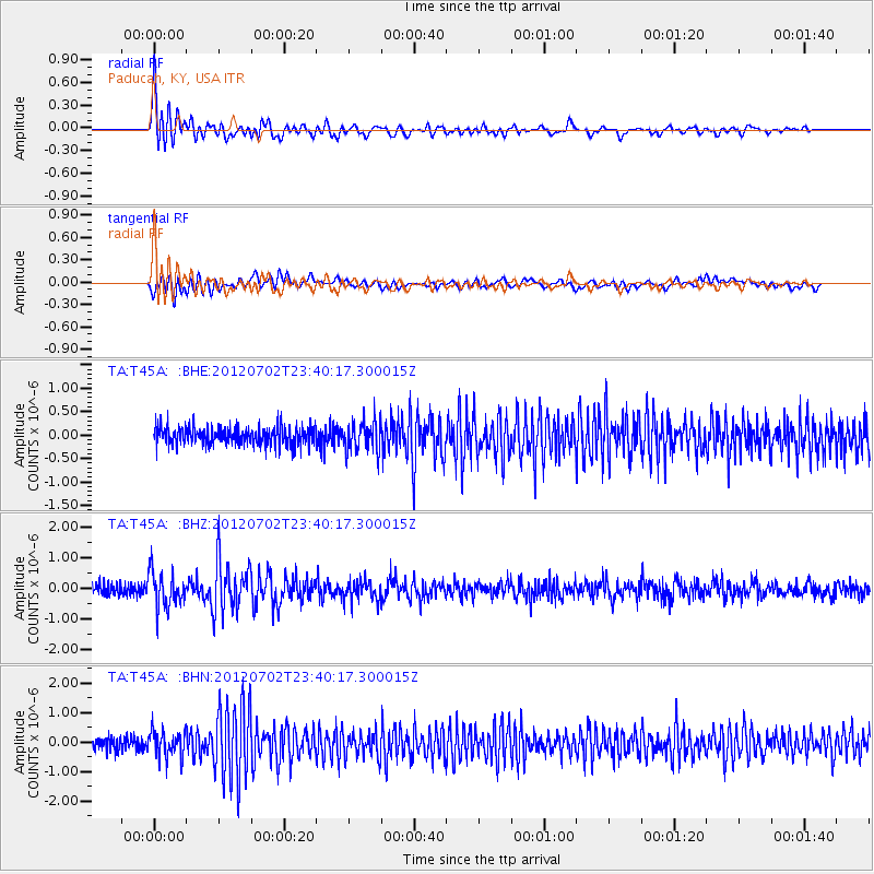
T45A Paducah, KY, USA - Earthquake Result Viewer
*The percent match for this event was below the threshold and hence no stack was calculated.
| Earthquake location: |
Near Coast Of Peru |
| Earthquake latitude/longitude: |
-14.4/-75.6 |
| Earthquake time(UTC): |
2012/07/02 (184) 23:31:37 GMT |
| Earthquake Depth: |
40 km |
| Earthquake Magnitude: |
6.0 MB, 5.2 MS, 5.7 MW, 5.6 MW |
| Earthquake Catalog/Contributor: |
WHDF/NEIC |
|
| Network: |
TA USArray Transportable Network (new EarthScope stations) |
| Station: |
T45A Paducah, KY, USA |
| Lat/Lon: |
37.02 N/88.64 W |
| Elevation: |
119 m |
|
| Distance: |
52.6 deg |
| Az: |
346.858 deg |
| Baz: |
164.024 deg |
| Ray Param: |
$rayparam |
*The percent match for this event was below the threshold and hence was not used in the summary stack. |
|
| Radial Match: |
78.3796 % |
| Radial Bump: |
400 |
| Transverse Match: |
70.14352 % |
| Transverse Bump: |
400 |
| SOD ConfigId: |
463687 |
| Insert Time: |
2013-02-20 18:26:27.351 +0000 |
| GWidth: |
2.5 |
| Max Bumps: |
400 |
| Tol: |
0.001 |
|
Signal To Noise
| Channel | StoN | STA | LTA |
| TA:T45A: :BHZ:20120702T23:40:17.300015Z | 3.0211916 | 5.771571E-7 | 1.9103625E-7 |
| TA:T45A: :BHN:20120702T23:40:17.300015Z | 2.1134236 | 4.3416904E-7 | 2.0543399E-7 |
| TA:T45A: :BHE:20120702T23:40:17.300015Z | 1.6493672 | 3.166949E-7 | 1.9200994E-7 |
| Arrivals |
| Ps | |
| PpPs | |
| PsPs/PpSs | |


