You are here: Home > Network List > TA - USArray Transportable Network (new EarthScope stations) Stations List
> Station T46A Princeton, KY, USA > Earthquake Result Viewer
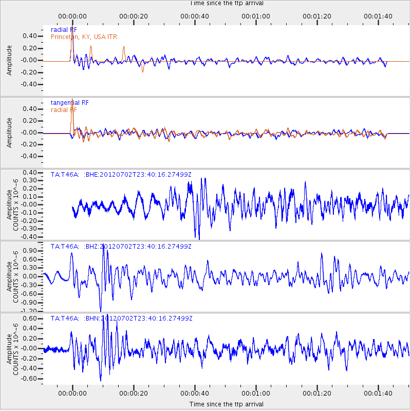
T46A Princeton, KY, USA - Earthquake Result Viewer
*The percent match for this event was below the threshold and hence no stack was calculated.
| Earthquake location: |
Near Coast Of Peru |
| Earthquake latitude/longitude: |
-14.4/-75.6 |
| Earthquake time(UTC): |
2012/07/02 (184) 23:31:37 GMT |
| Earthquake Depth: |
40 km |
| Earthquake Magnitude: |
6.0 MB, 5.2 MS, 5.7 MW, 5.6 MW |
| Earthquake Catalog/Contributor: |
WHDF/NEIC |
|
| Network: |
TA USArray Transportable Network (new EarthScope stations) |
| Station: |
T46A Princeton, KY, USA |
| Lat/Lon: |
37.04 N/87.89 W |
| Elevation: |
169 m |
|
| Distance: |
52.5 deg |
| Az: |
347.594 deg |
| Baz: |
164.922 deg |
| Ray Param: |
$rayparam |
*The percent match for this event was below the threshold and hence was not used in the summary stack. |
|
| Radial Match: |
75.19706 % |
| Radial Bump: |
400 |
| Transverse Match: |
66.79769 % |
| Transverse Bump: |
400 |
| SOD ConfigId: |
463687 |
| Insert Time: |
2013-02-20 18:26:28.845 +0000 |
| GWidth: |
2.5 |
| Max Bumps: |
400 |
| Tol: |
0.001 |
|
Signal To Noise
| Channel | StoN | STA | LTA |
| TA:T46A: :BHZ:20120702T23:40:16.27499Z | 4.8007965 | 4.0111203E-7 | 8.355114E-8 |
| TA:T46A: :BHN:20120702T23:40:16.27499Z | 2.6327465 | 2.0701795E-7 | 7.863194E-8 |
| TA:T46A: :BHE:20120702T23:40:16.27499Z | 1.6778595 | 1.1642911E-7 | 6.9391454E-8 |
| Arrivals |
| Ps | |
| PpPs | |
| PsPs/PpSs | |


