You are here: Home > Network List > TA - USArray Transportable Network (new EarthScope stations) Stations List
> Station 150A Eclectic, AL, USA > Earthquake Result Viewer
150A Eclectic, AL, USA - Earthquake Result Viewer
| Earthquake location: |
Near Coast Of Peru |
| Earthquake latitude/longitude: |
-14.4/-75.6 |
| Earthquake time(UTC): |
2012/07/02 (184) 23:31:37 GMT |
| Earthquake Depth: |
40 km |
| Earthquake Magnitude: |
6.0 MB, 5.2 MS, 5.7 MW, 5.6 MW |
| Earthquake Catalog/Contributor: |
WHDF/NEIC |
|
| Network: |
TA USArray Transportable Network (new EarthScope stations) |
| Station: |
150A Eclectic, AL, USA |
| Lat/Lon: |
32.61 N/86.02 W |
| Elevation: |
145 m |
|
| Distance: |
47.8 deg |
| Az: |
348.107 deg |
| Baz: |
166.315 deg |
| Ray Param: |
0.069665216 |
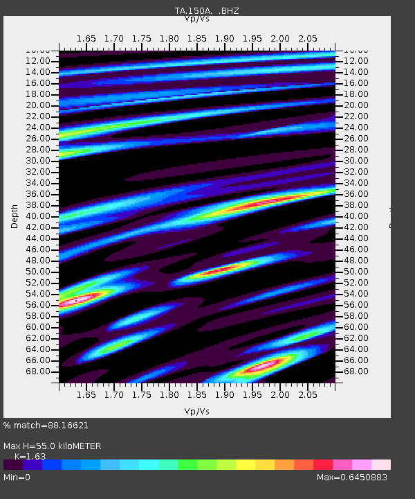
| Estimated Moho Depth: |
55.0 km |
| Estimated Crust Vp/Vs: |
1.63 |
| Assumed Crust Vp: |
6.565 km/s |
| Estimated Crust Vs: |
4.027 km/s |
| Estimated Crust Poisson's Ratio: |
0.20 |
|
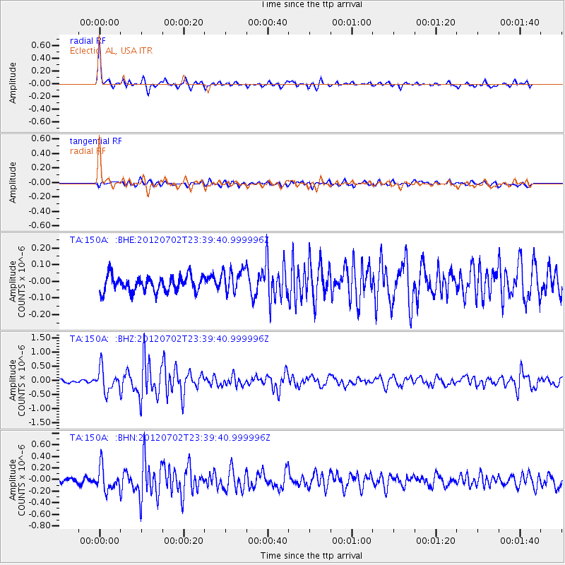
| Radial Match: |
88.16621 % |
| Radial Bump: |
372 |
| Transverse Match: |
59.113316 % |
| Transverse Bump: |
400 |
| SOD ConfigId: |
463687 |
| Insert Time: |
2013-02-20 18:29:02.327 +0000 |
| GWidth: |
2.5 |
| Max Bumps: |
400 |
| Tol: |
0.001 |
|
Signal To Noise
| Channel | StoN | STA | LTA |
| TA:150A: :BHZ:20120702T23:39:40.999996Z | 8.896995 | 4.1819422E-7 | 4.7003986E-8 |
| TA:150A: :BHN:20120702T23:39:40.999996Z | 5.1515226 | 2.0567145E-7 | 3.99244E-8 |
| TA:150A: :BHE:20120702T23:39:40.999996Z | 1.5513636 | 7.1888905E-8 | 4.6339178E-8 |
| Arrivals |
| Ps | 5.7 SECOND |
| PpPs | 21 SECOND |
| PsPs/PpSs | 26 SECOND |


