You are here: Home > Network List > TA - USArray Transportable Network (new EarthScope stations) Stations List
> Station 554A Perry, FL, USA > Earthquake Result Viewer
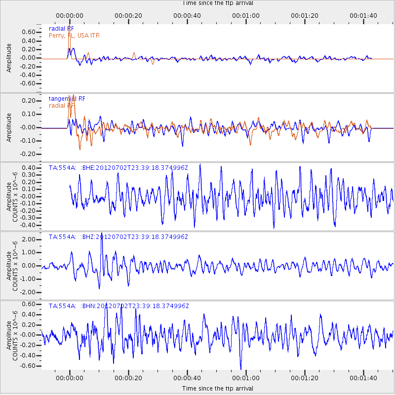
554A Perry, FL, USA - Earthquake Result Viewer
*The percent match for this event was below the threshold and hence no stack was calculated.
| Earthquake location: |
Near Coast Of Peru |
| Earthquake latitude/longitude: |
-14.4/-75.6 |
| Earthquake time(UTC): |
2012/07/02 (184) 23:31:37 GMT |
| Earthquake Depth: |
40 km |
| Earthquake Magnitude: |
6.0 MB, 5.2 MS, 5.7 MW, 5.6 MW |
| Earthquake Catalog/Contributor: |
WHDF/NEIC |
|
| Network: |
TA USArray Transportable Network (new EarthScope stations) |
| Station: |
554A Perry, FL, USA |
| Lat/Lon: |
30.08 N/83.68 W |
| Elevation: |
12 m |
|
| Distance: |
44.9 deg |
| Az: |
350.06 deg |
| Baz: |
168.874 deg |
| Ray Param: |
$rayparam |
*The percent match for this event was below the threshold and hence was not used in the summary stack. |
|
| Radial Match: |
76.54896 % |
| Radial Bump: |
400 |
| Transverse Match: |
62.669273 % |
| Transverse Bump: |
400 |
| SOD ConfigId: |
463687 |
| Insert Time: |
2013-02-20 18:30:48.841 +0000 |
| GWidth: |
2.5 |
| Max Bumps: |
400 |
| Tol: |
0.001 |
|
Signal To Noise
| Channel | StoN | STA | LTA |
| TA:554A: :BHZ:20120702T23:39:18.374996Z | 2.5739033 | 5.048697E-7 | 1.9614943E-7 |
| TA:554A: :BHN:20120702T23:39:18.374996Z | 1.7352736 | 1.7215223E-7 | 9.920754E-8 |
| TA:554A: :BHE:20120702T23:39:18.374996Z | 1.4798932 | 1.8337855E-7 | 1.2391337E-7 |
| Arrivals |
| Ps | |
| PpPs | |
| PsPs/PpSs | |


