You are here: Home > Network List > TA - USArray Transportable Network (new EarthScope stations) Stations List
> Station 655A Horseshoe Beach, FL, USA > Earthquake Result Viewer
655A Horseshoe Beach, FL, USA - Earthquake Result Viewer

| Earthquake location: |
Near Coast Of Peru |
| Earthquake latitude/longitude: |
-14.4/-75.6 |
| Earthquake time(UTC): |
2012/07/02 (184) 23:31:37 GMT |
| Earthquake Depth: |
40 km |
| Earthquake Magnitude: |
6.0 MB, 5.2 MS, 5.7 MW, 5.6 MW |
| Earthquake Catalog/Contributor: |
WHDF/NEIC |
|
| Network: |
TA USArray Transportable Network (new EarthScope stations) |
| Station: |
655A Horseshoe Beach, FL, USA |
| Lat/Lon: |
29.51 N/83.26 W |
| Elevation: |
6.0 m |
|
| Distance: |
44.3 deg |
| Az: |
350.427 deg |
| Baz: |
169.347 deg |
| Ray Param: |
0.07191429 |
| Estimated Moho Depth: |
13.25 km |
| Estimated Crust Vp/Vs: |
1.61 |
| Assumed Crust Vp: |
5.989 km/s |
| Estimated Crust Vs: |
3.732 km/s |
| Estimated Crust Poisson's Ratio: |
0.18 |
|
| Radial Match: |
82.40196 % |
| Radial Bump: |
400 |
| Transverse Match: |
57.959133 % |
| Transverse Bump: |
400 |
| SOD ConfigId: |
463687 |
| Insert Time: |
2013-02-20 18:31:00.959 +0000 |
| GWidth: |
2.5 |
| Max Bumps: |
400 |
| Tol: |
0.001 |
|
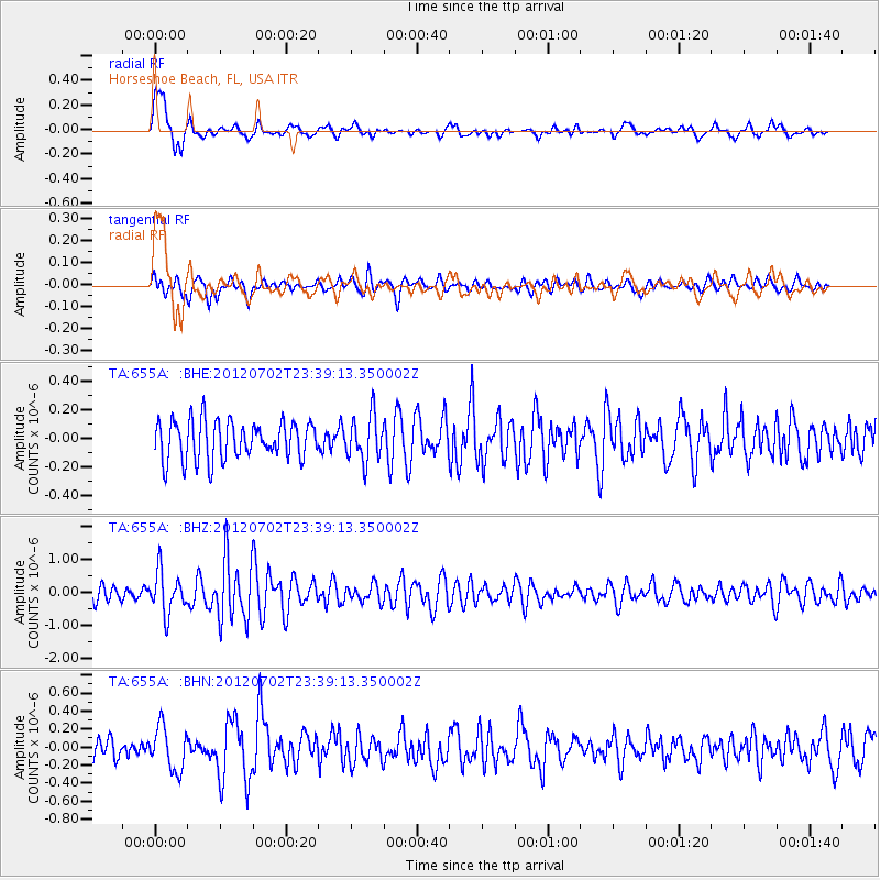
Signal To Noise
| Channel | StoN | STA | LTA |
| TA:655A: :BHZ:20120702T23:39:13.350002Z | 3.478251 | 6.2372567E-7 | 1.7932165E-7 |
| TA:655A: :BHN:20120702T23:39:13.350002Z | 2.2854 | 2.4005075E-7 | 1.0503665E-7 |
| TA:655A: :BHE:20120702T23:39:13.350002Z | 1.1700459 | 1.5732623E-7 | 1.3446159E-7 |
| Arrivals |
| Ps | 1.4 SECOND |
| PpPs | 5.4 SECOND |
| PsPs/PpSs | 6.8 SECOND |


