You are here: Home > Network List > TA - USArray Transportable Network (new EarthScope stations) Stations List
> Station 253A Americus, GA, USA > Earthquake Result Viewer
253A Americus, GA, USA - Earthquake Result Viewer
| Earthquake location: |
Near Coast Of Peru |
| Earthquake latitude/longitude: |
-14.4/-75.6 |
| Earthquake time(UTC): |
2012/07/02 (184) 23:31:37 GMT |
| Earthquake Depth: |
40 km |
| Earthquake Magnitude: |
6.0 MB, 5.2 MS, 5.7 MW, 5.6 MW |
| Earthquake Catalog/Contributor: |
WHDF/NEIC |
|
| Network: |
TA USArray Transportable Network (new EarthScope stations) |
| Station: |
253A Americus, GA, USA |
| Lat/Lon: |
32.06 N/84.13 W |
| Elevation: |
136 m |
|
| Distance: |
46.9 deg |
| Az: |
350.072 deg |
| Baz: |
168.654 deg |
| Ray Param: |
0.070230685 |
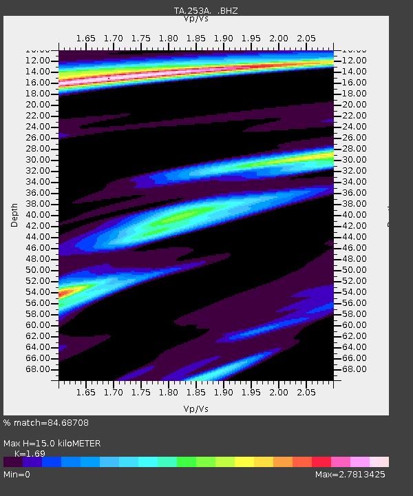
| Estimated Moho Depth: |
15.0 km |
| Estimated Crust Vp/Vs: |
1.69 |
| Assumed Crust Vp: |
6.719 km/s |
| Estimated Crust Vs: |
3.976 km/s |
| Estimated Crust Poisson's Ratio: |
0.23 |
|
| Radial Match: |
84.68708 % |
| Radial Bump: |
378 |
| Transverse Match: |
62.89902 % |
| Transverse Bump: |
400 |
| SOD ConfigId: |
463687 |
| Insert Time: |
2013-02-20 18:31:27.539 +0000 |
| GWidth: |
2.5 |
| Max Bumps: |
400 |
| Tol: |
0.001 |
|
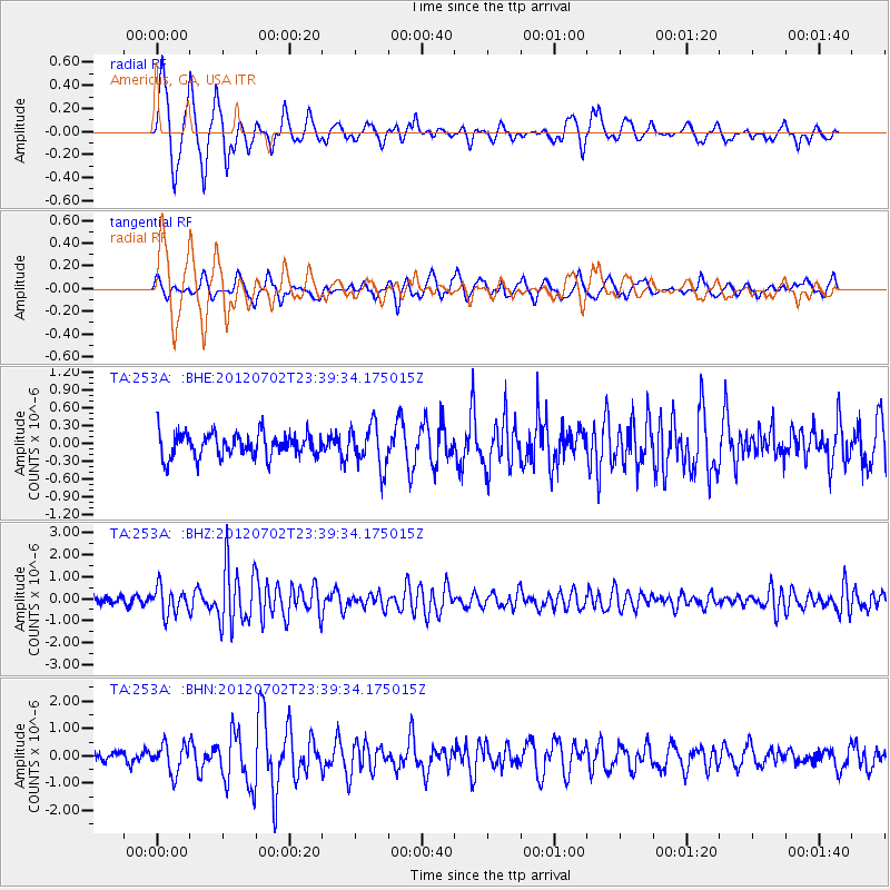
Signal To Noise
| Channel | StoN | STA | LTA |
| TA:253A: :BHZ:20120702T23:39:34.175015Z | 4.198543 | 6.134878E-7 | 1.4611922E-7 |
| TA:253A: :BHN:20120702T23:39:34.175015Z | 2.8723583 | 5.1687255E-7 | 1.7994711E-7 |
| TA:253A: :BHE:20120702T23:39:34.175015Z | 1.7243704 | 3.5253103E-7 | 2.0444044E-7 |
| Arrivals |
| Ps | 1.7 SECOND |
| PpPs | 5.6 SECOND |
| PsPs/PpSs | 7.2 SECOND |


