You are here: Home > Network List > TA - USArray Transportable Network (new EarthScope stations) Stations List
> Station 254A Abbeville, GA, USA > Earthquake Result Viewer
254A Abbeville, GA, USA - Earthquake Result Viewer
| Earthquake location: |
Near Coast Of Peru |
| Earthquake latitude/longitude: |
-14.4/-75.6 |
| Earthquake time(UTC): |
2012/07/02 (184) 23:31:37 GMT |
| Earthquake Depth: |
40 km |
| Earthquake Magnitude: |
6.0 MB, 5.2 MS, 5.7 MW, 5.6 MW |
| Earthquake Catalog/Contributor: |
WHDF/NEIC |
|
| Network: |
TA USArray Transportable Network (new EarthScope stations) |
| Station: |
254A Abbeville, GA, USA |
| Lat/Lon: |
31.95 N/83.29 W |
| Elevation: |
78 m |
|
| Distance: |
46.7 deg |
| Az: |
351.003 deg |
| Baz: |
169.733 deg |
| Ray Param: |
0.0703948 |
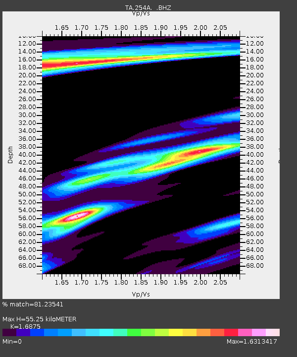
| Estimated Moho Depth: |
55.25 km |
| Estimated Crust Vp/Vs: |
1.69 |
| Assumed Crust Vp: |
6.565 km/s |
| Estimated Crust Vs: |
3.89 km/s |
| Estimated Crust Poisson's Ratio: |
0.23 |
|
| Radial Match: |
81.23541 % |
| Radial Bump: |
355 |
| Transverse Match: |
64.97346 % |
| Transverse Bump: |
400 |
| SOD ConfigId: |
463687 |
| Insert Time: |
2013-02-20 18:31:52.386 +0000 |
| GWidth: |
2.5 |
| Max Bumps: |
400 |
| Tol: |
0.001 |
|
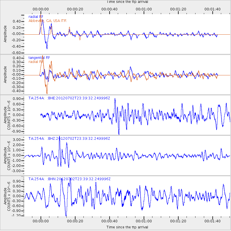
Signal To Noise
| Channel | StoN | STA | LTA |
| TA:254A: :BHZ:20120702T23:39:32.249996Z | 6.1109962 | 7.5367683E-7 | 1.2333125E-7 |
| TA:254A: :BHN:20120702T23:39:32.249996Z | 1.9921488 | 3.932342E-7 | 1.9739198E-7 |
| TA:254A: :BHE:20120702T23:39:32.249996Z | 1.331436 | 1.563607E-7 | 1.17437644E-7 |
| Arrivals |
| Ps | 6.2 SECOND |
| PpPs | 21 SECOND |
| PsPs/PpSs | 27 SECOND |


