You are here: Home > Network List > UW - Pacific Northwest Regional Seismic Network Stations List
> Station UMAT Pilot Rock, OR, USA > Earthquake Result Viewer
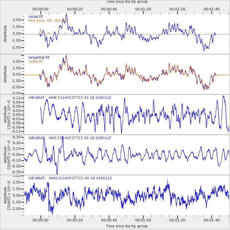
UMAT Pilot Rock, OR, USA - Earthquake Result Viewer
*The percent match for this event was below the threshold and hence no stack was calculated.
| Earthquake location: |
Near Coast Of Guatemala |
| Earthquake latitude/longitude: |
13.4/-90.9 |
| Earthquake time(UTC): |
2014/05/25 (145) 22:36:19 GMT |
| Earthquake Depth: |
30 km |
| Earthquake Magnitude: |
5.3 MW |
| Earthquake Catalog/Contributor: |
ISC/ISC |
|
| Network: |
UW Pacific Northwest Regional Seismic Network |
| Station: |
UMAT Pilot Rock, OR, USA |
| Lat/Lon: |
45.29 N/118.96 W |
| Elevation: |
1318 m |
|
| Distance: |
39.7 deg |
| Az: |
328.676 deg |
| Baz: |
134.219 deg |
| Ray Param: |
$rayparam |
*The percent match for this event was below the threshold and hence was not used in the summary stack. |
|
| Radial Match: |
50.65286 % |
| Radial Bump: |
400 |
| Transverse Match: |
50.619633 % |
| Transverse Bump: |
400 |
| SOD ConfigId: |
3390531 |
| Insert Time: |
2019-04-12 01:14:54.293 +0000 |
| GWidth: |
2.5 |
| Max Bumps: |
400 |
| Tol: |
0.001 |
|
Signal To Noise
| Channel | StoN | STA | LTA |
| UW:UMAT: :HHZ:20140525T22:43:18.918011Z | 1.9142445 | 1.3186342E-7 | 6.8885356E-8 |
| UW:UMAT: :HHN:20140525T22:43:18.918011Z | 1.4372208 | 9.387413E-7 | 6.531643E-7 |
| UW:UMAT: :HHE:20140525T22:43:18.918011Z | 0.976458 | 5.003633E-8 | 5.1242687E-8 |
| Arrivals |
| Ps | |
| PpPs | |
| PsPs/PpSs | |


