You are here: Home > Network List > G - GEOSCOPE Stations List
> Station SSB Saint Sauveur Badole, France > Earthquake Result Viewer
SSB Saint Sauveur Badole, France - Earthquake Result Viewer
| Earthquake location: |
North Of Honduras |
| Earthquake latitude/longitude: |
16.7/-86.2 |
| Earthquake time(UTC): |
2009/05/28 (148) 08:24:45 GMT |
| Earthquake Depth: |
10 km |
| Earthquake Magnitude: |
6.7 MB, 7.2 MS, 7.3 MW, 7.3 MW |
| Earthquake Catalog/Contributor: |
WHDF/NEIC |
|
| Network: |
G GEOSCOPE |
| Station: |
SSB Saint Sauveur Badole, France |
| Lat/Lon: |
45.28 N/4.54 E |
| Elevation: |
700 m |
|
| Distance: |
78.9 deg |
| Az: |
46.017 deg |
| Baz: |
282.422 deg |
| Ray Param: |
0.049360473 |
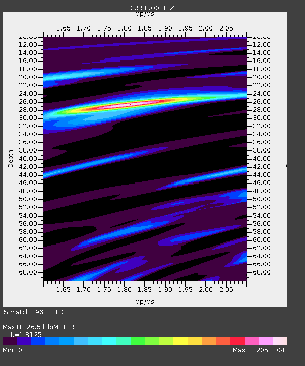
| Estimated Moho Depth: |
26.5 km |
| Estimated Crust Vp/Vs: |
1.81 |
| Assumed Crust Vp: |
6.1 km/s |
| Estimated Crust Vs: |
3.366 km/s |
| Estimated Crust Poisson's Ratio: |
0.28 |
|
| Radial Match: |
96.11313 % |
| Radial Bump: |
400 |
| Transverse Match: |
86.992226 % |
| Transverse Bump: |
400 |
| SOD ConfigId: |
2648 |
| Insert Time: |
2010-02-27 00:12:05.356 +0000 |
| GWidth: |
2.5 |
| Max Bumps: |
400 |
| Tol: |
0.001 |
|
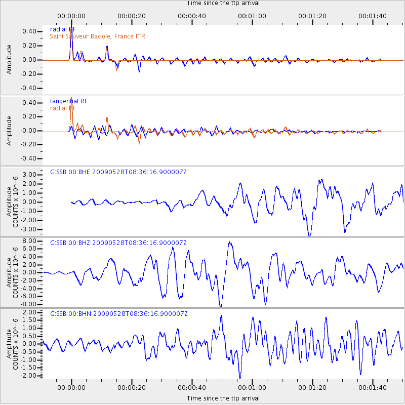
Signal To Noise
| Channel | StoN | STA | LTA |
| G:SSB:00:BHZ:20090528T08:36:16.900007Z | 8.930921 | 1.3886274E-6 | 1.5548537E-7 |
| G:SSB:00:BHN:20090528T08:36:16.900007Z | 1.6864963 | 2.3126353E-7 | 1.3712662E-7 |
| G:SSB:00:BHE:20090528T08:36:16.900007Z | 3.038015 | 4.6508555E-7 | 1.5308864E-7 |
| Arrivals |
| Ps | 3.6 SECOND |
| PpPs | 12 SECOND |
| PsPs/PpSs | 16 SECOND |


