You are here: Home > Network List > TA - USArray Transportable Network (new EarthScope stations) Stations List
> Station S50A Richmond, KY, USA > Earthquake Result Viewer
S50A Richmond, KY, USA - Earthquake Result Viewer
| Earthquake location: |
Near Coast Of Peru |
| Earthquake latitude/longitude: |
-14.4/-75.6 |
| Earthquake time(UTC): |
2012/07/02 (184) 23:31:37 GMT |
| Earthquake Depth: |
40 km |
| Earthquake Magnitude: |
6.0 MB, 5.2 MS, 5.7 MW, 5.6 MW |
| Earthquake Catalog/Contributor: |
WHDF/NEIC |
|
| Network: |
TA USArray Transportable Network (new EarthScope stations) |
| Station: |
S50A Richmond, KY, USA |
| Lat/Lon: |
37.68 N/84.40 W |
| Elevation: |
300 m |
|
| Distance: |
52.5 deg |
| Az: |
351.195 deg |
| Baz: |
169.226 deg |
| Ray Param: |
0.06664882 |
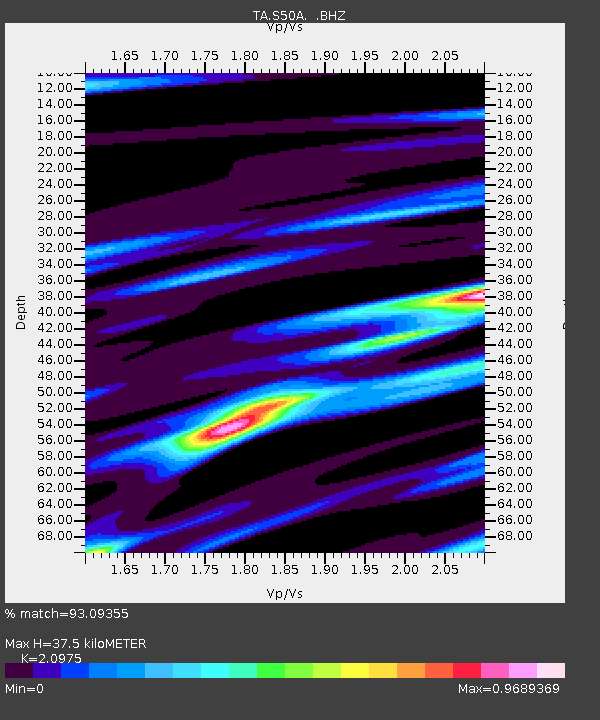
| Estimated Moho Depth: |
37.5 km |
| Estimated Crust Vp/Vs: |
2.10 |
| Assumed Crust Vp: |
6.476 km/s |
| Estimated Crust Vs: |
3.087 km/s |
| Estimated Crust Poisson's Ratio: |
0.35 |
|
| Radial Match: |
93.09355 % |
| Radial Bump: |
325 |
| Transverse Match: |
77.61604 % |
| Transverse Bump: |
400 |
| SOD ConfigId: |
463687 |
| Insert Time: |
2013-02-20 18:35:21.620 +0000 |
| GWidth: |
2.5 |
| Max Bumps: |
400 |
| Tol: |
0.001 |
|
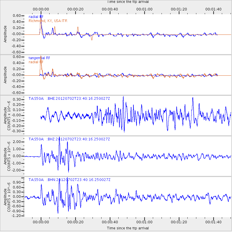
Signal To Noise
| Channel | StoN | STA | LTA |
| TA:S50A: :BHZ:20120702T23:40:16.250027Z | 10.317197 | 6.9348323E-7 | 6.721625E-8 |
| TA:S50A: :BHN:20120702T23:40:16.250027Z | 6.3821974 | 3.1829126E-7 | 4.9871737E-8 |
| TA:S50A: :BHE:20120702T23:40:16.250027Z | 1.5401119 | 7.9823515E-8 | 5.1829687E-8 |
| Arrivals |
| Ps | 6.7 SECOND |
| PpPs | 17 SECOND |
| PsPs/PpSs | 24 SECOND |


