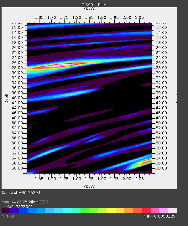
SSB Saint Sauveur Badole, France - Earthquake Result Viewer

Earthquake location: Off East Coast Of Kamchatka
Earthquake latitude/longitude: 52.9/160.1
Earthquake time(UTC): 1998/06/01 (152) 05:34:03 GMT
Earthquake Depth: 44 km
Earthquake Magnitude: 6.2 MB, 6.3 MS, 6.5 UNKNOWN, 6.4 MW
Earthquake Catalog/Contributor: WHDF/NEIC
Network: G GEOSCOPE
Station: SSB Saint Sauveur Badole, France
Lat/Lon: 45.28 N/4.54 E
Elevation: 700 m
Distance: 80.0 deg
Az: 342.72 deg
Baz: 14.769 deg
Ray Param: 0.048516657
Estimated Moho Depth: 26.75 km
Estimated Crust Vp/Vs: 1.74
Assumed Crust Vp: 6.1 km/s
Estimated Crust Vs: 3.511 km/s
Estimated Crust Poisson's Ratio: 0.25
Radial Match: 89.75304 %
Radial Bump: 400
Transverse Match: 78.7722 %
Transverse Bump: 400
SOD ConfigId: 4480
Insert Time: 2010-02-27 00:12:09.937 +0000
GWidth: 2.5
Max Bumps: 400
Tol: 0.001

Signal To Noise

ChannelStoNSTALTA
G:SSB: :BHN:19980601T05:45:37.083008Z0.51546111.3563708E-62.6313737E-6
G:SSB: :BHE:19980601T05:45:37.083008Z0.970564078.516243E-78.774529E-7
G:SSB: :BHZ:19980601T05:45:37.083008Z1.56457145.213005E-73.331906E-7
Arrivals
Ps3.3 SECOND
PpPs12 SECOND
PsPs/PpSs15 SECOND