You are here: Home > Network List > TA - USArray Transportable Network (new EarthScope stations) Stations List
> Station R51A Hillsboro, KY, USA > Earthquake Result Viewer
R51A Hillsboro, KY, USA - Earthquake Result Viewer
| Earthquake location: |
Near Coast Of Peru |
| Earthquake latitude/longitude: |
-14.4/-75.6 |
| Earthquake time(UTC): |
2012/07/02 (184) 23:31:37 GMT |
| Earthquake Depth: |
40 km |
| Earthquake Magnitude: |
6.0 MB, 5.2 MS, 5.7 MW, 5.6 MW |
| Earthquake Catalog/Contributor: |
WHDF/NEIC |
|
| Network: |
TA USArray Transportable Network (new EarthScope stations) |
| Station: |
R51A Hillsboro, KY, USA |
| Lat/Lon: |
38.30 N/83.58 W |
| Elevation: |
231 m |
|
| Distance: |
53.0 deg |
| Az: |
352.131 deg |
| Baz: |
170.294 deg |
| Ray Param: |
0.06632289 |
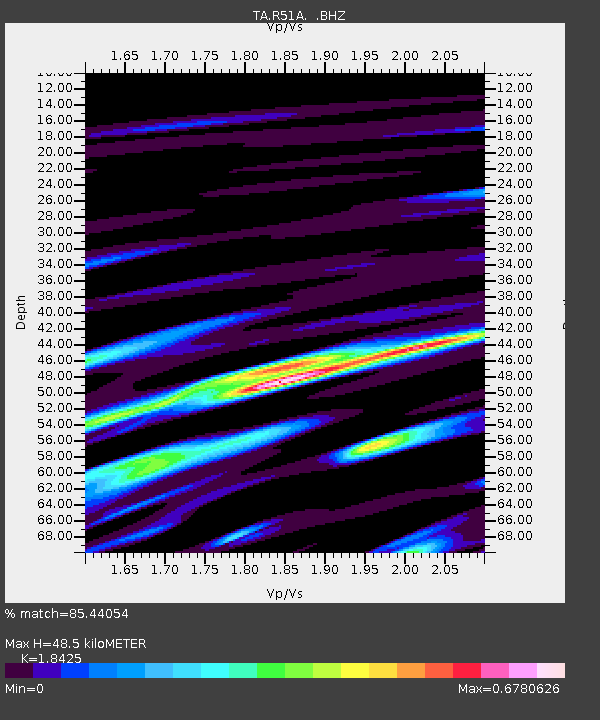
| Estimated Moho Depth: |
48.5 km |
| Estimated Crust Vp/Vs: |
1.84 |
| Assumed Crust Vp: |
6.232 km/s |
| Estimated Crust Vs: |
3.382 km/s |
| Estimated Crust Poisson's Ratio: |
0.29 |
|
| Radial Match: |
85.44054 % |
| Radial Bump: |
400 |
| Transverse Match: |
69.48224 % |
| Transverse Bump: |
400 |
| SOD ConfigId: |
463687 |
| Insert Time: |
2013-02-20 18:36:56.633 +0000 |
| GWidth: |
2.5 |
| Max Bumps: |
400 |
| Tol: |
0.001 |
|

Signal To Noise
| Channel | StoN | STA | LTA |
| TA:R51A: :BHZ:20120702T23:40:19.89999Z | 9.582638 | 5.1156735E-7 | 5.3384813E-8 |
| TA:R51A: :BHN:20120702T23:40:19.89999Z | 4.8698854 | 2.9220922E-7 | 6.00033E-8 |
| TA:R51A: :BHE:20120702T23:40:19.89999Z | 1.7368417 | 9.83427E-8 | 5.662157E-8 |
| Arrivals |
| Ps | 6.9 SECOND |
| PpPs | 21 SECOND |
| PsPs/PpSs | 28 SECOND |


