You are here: Home > Network List > G - GEOSCOPE Stations List
> Station SSB Saint Sauveur Badole, France > Earthquake Result Viewer
SSB Saint Sauveur Badole, France - Earthquake Result Viewer
| Earthquake location: |
Near Coast Of Ecuador |
| Earthquake latitude/longitude: |
-0.6/-80.4 |
| Earthquake time(UTC): |
1998/08/04 (216) 18:59:20 GMT |
| Earthquake Depth: |
33 km |
| Earthquake Magnitude: |
6.2 MB, 7.1 MS, 7.1 UNKNOWN, 7.0 ME |
| Earthquake Catalog/Contributor: |
WHDF/NEIC |
|
| Network: |
G GEOSCOPE |
| Station: |
SSB Saint Sauveur Badole, France |
| Lat/Lon: |
45.28 N/4.54 E |
| Elevation: |
700 m |
|
| Distance: |
86.8 deg |
| Az: |
44.777 deg |
| Baz: |
265.993 deg |
| Ray Param: |
0.043712437 |
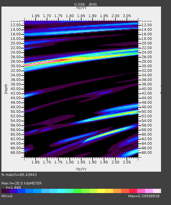
| Estimated Moho Depth: |
28.5 km |
| Estimated Crust Vp/Vs: |
1.66 |
| Assumed Crust Vp: |
6.1 km/s |
| Estimated Crust Vs: |
3.664 km/s |
| Estimated Crust Poisson's Ratio: |
0.22 |
|
| Radial Match: |
98.43943 % |
| Radial Bump: |
251 |
| Transverse Match: |
92.72344 % |
| Transverse Bump: |
400 |
| SOD ConfigId: |
4480 |
| Insert Time: |
2010-02-27 00:12:19.109 +0000 |
| GWidth: |
2.5 |
| Max Bumps: |
400 |
| Tol: |
0.001 |
|

Signal To Noise
| Channel | StoN | STA | LTA |
| G:SSB: :BHN:19980804T19:11:30.058008Z | 6.9829545 | 1.44732985E-5 | 2.0726611E-6 |
| G:SSB: :BHE:19980804T19:11:30.058008Z | 4.9799113 | 5.265531E-7 | 1.0573544E-7 |
| G:SSB: :BHZ:19980804T19:11:30.058008Z | 8.348498 | 4.6548816E-6 | 5.575711E-7 |
| Arrivals |
| Ps | 3.2 SECOND |
| PpPs | 12 SECOND |
| PsPs/PpSs | 15 SECOND |


