You are here: Home > Network List > UW - Pacific Northwest Regional Seismic Network Stations List
> Station LEBA Lebam, WA, USA > Earthquake Result Viewer
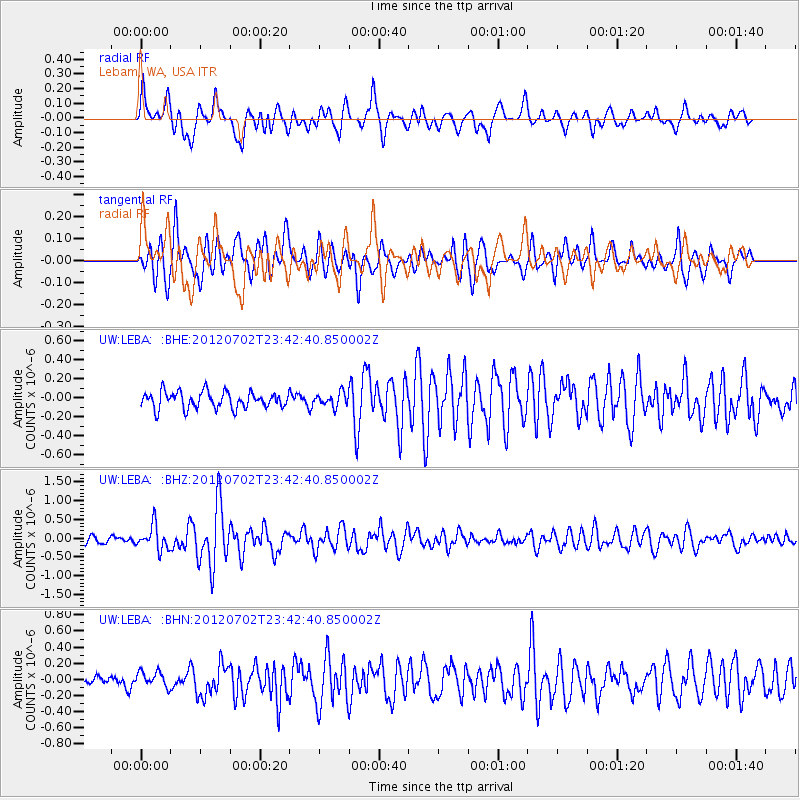
LEBA Lebam, WA, USA - Earthquake Result Viewer
*The percent match for this event was below the threshold and hence no stack was calculated.
| Earthquake location: |
Near Coast Of Peru |
| Earthquake latitude/longitude: |
-14.4/-75.6 |
| Earthquake time(UTC): |
2012/07/02 (184) 23:31:37 GMT |
| Earthquake Depth: |
40 km |
| Earthquake Magnitude: |
6.0 MB, 5.2 MS, 5.7 MW, 5.6 MW |
| Earthquake Catalog/Contributor: |
WHDF/NEIC |
|
| Network: |
UW Pacific Northwest Regional Seismic Network |
| Station: |
LEBA Lebam, WA, USA |
| Lat/Lon: |
46.55 N/123.56 W |
| Elevation: |
73 m |
|
| Distance: |
74.4 deg |
| Az: |
327.845 deg |
| Baz: |
131.661 deg |
| Ray Param: |
$rayparam |
*The percent match for this event was below the threshold and hence was not used in the summary stack. |
|
| Radial Match: |
76.524826 % |
| Radial Bump: |
400 |
| Transverse Match: |
72.461174 % |
| Transverse Bump: |
400 |
| SOD ConfigId: |
463687 |
| Insert Time: |
2013-02-20 18:40:13.894 +0000 |
| GWidth: |
2.5 |
| Max Bumps: |
400 |
| Tol: |
0.001 |
|
Signal To Noise
| Channel | StoN | STA | LTA |
| UW:LEBA: :BHZ:20120702T23:42:40.850002Z | 4.611898 | 3.227251E-7 | 6.9976636E-8 |
| UW:LEBA: :BHN:20120702T23:42:40.850002Z | 1.8445247 | 9.699165E-8 | 5.2583545E-8 |
| UW:LEBA: :BHE:20120702T23:42:40.850002Z | 0.81748205 | 7.075547E-8 | 8.655293E-8 |
| Arrivals |
| Ps | |
| PpPs | |
| PsPs/PpSs | |


