You are here: Home > Network List > IW - Intermountain West Stations List
> Station MOOW Moose Ponds, Wyoming, USA > Earthquake Result Viewer
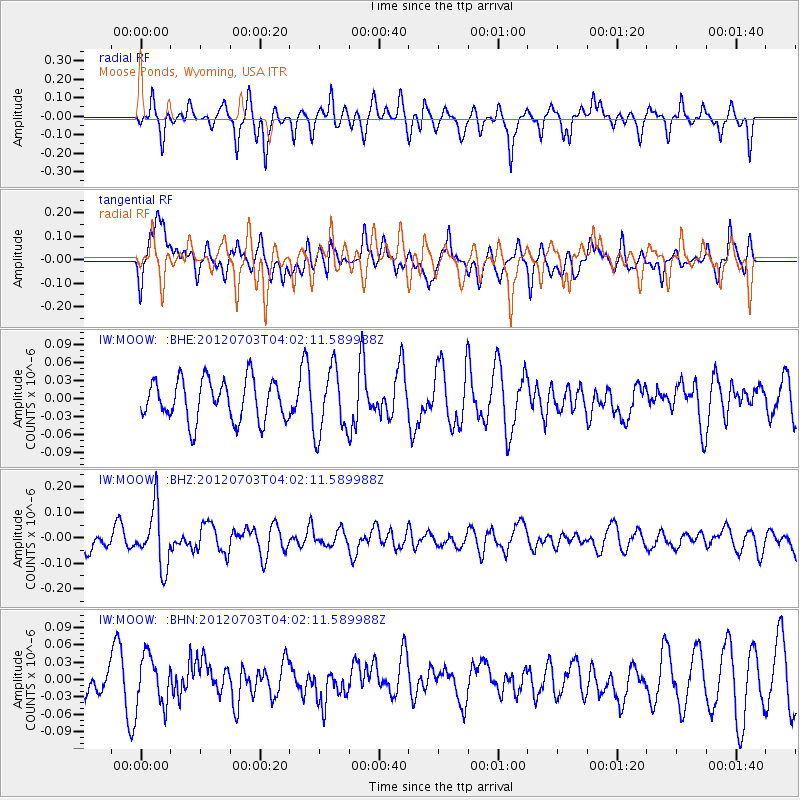
MOOW Moose Ponds, Wyoming, USA - Earthquake Result Viewer
*The percent match for this event was below the threshold and hence no stack was calculated.
| Earthquake location: |
Solomon Islands |
| Earthquake latitude/longitude: |
-10.8/163.3 |
| Earthquake time(UTC): |
2012/07/03 (185) 03:49:33 GMT |
| Earthquake Depth: |
92 km |
| Earthquake Magnitude: |
5.6 MB, 5.5 MW, 5.5 MW |
| Earthquake Catalog/Contributor: |
WHDF/NEIC |
|
| Network: |
IW Intermountain West |
| Station: |
MOOW Moose Ponds, Wyoming, USA |
| Lat/Lon: |
43.75 N/110.74 W |
| Elevation: |
2128 m |
|
| Distance: |
94.5 deg |
| Az: |
46.474 deg |
| Baz: |
259.407 deg |
| Ray Param: |
$rayparam |
*The percent match for this event was below the threshold and hence was not used in the summary stack. |
|
| Radial Match: |
59.81062 % |
| Radial Bump: |
400 |
| Transverse Match: |
40.91742 % |
| Transverse Bump: |
400 |
| SOD ConfigId: |
463687 |
| Insert Time: |
2013-02-20 18:54:27.868 +0000 |
| GWidth: |
2.5 |
| Max Bumps: |
400 |
| Tol: |
0.001 |
|
Signal To Noise
| Channel | StoN | STA | LTA |
| IW:MOOW: :BHZ:20120703T04:02:11.589988Z | 2.8384364 | 1.1499457E-7 | 4.051335E-8 |
| IW:MOOW: :BHN:20120703T04:02:11.589988Z | 1.3168232 | 4.221136E-8 | 3.2055453E-8 |
| IW:MOOW: :BHE:20120703T04:02:11.589988Z | 1.6243819 | 5.5505243E-8 | 3.417007E-8 |
| Arrivals |
| Ps | |
| PpPs | |
| PsPs/PpSs | |


