You are here: Home > Network List > TA - USArray Transportable Network (new EarthScope stations) Stations List
> Station TPFO Pinon Flats, CA, USA > Earthquake Result Viewer
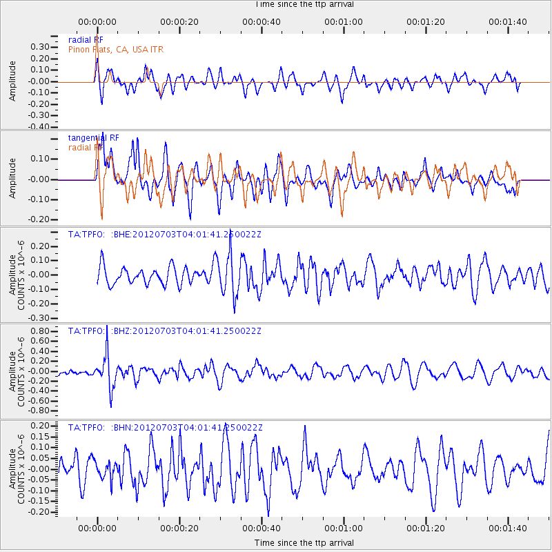
TPFO Pinon Flats, CA, USA - Earthquake Result Viewer
*The percent match for this event was below the threshold and hence no stack was calculated.
| Earthquake location: |
Solomon Islands |
| Earthquake latitude/longitude: |
-10.8/163.3 |
| Earthquake time(UTC): |
2012/07/03 (185) 03:49:33 GMT |
| Earthquake Depth: |
92 km |
| Earthquake Magnitude: |
5.6 MB, 5.5 MW, 5.5 MW |
| Earthquake Catalog/Contributor: |
WHDF/NEIC |
|
| Network: |
TA USArray Transportable Network (new EarthScope stations) |
| Station: |
TPFO Pinon Flats, CA, USA |
| Lat/Lon: |
33.61 N/116.45 W |
| Elevation: |
1275 m |
|
| Distance: |
87.9 deg |
| Az: |
55.384 deg |
| Baz: |
255.652 deg |
| Ray Param: |
$rayparam |
*The percent match for this event was below the threshold and hence was not used in the summary stack. |
|
| Radial Match: |
51.18345 % |
| Radial Bump: |
400 |
| Transverse Match: |
74.340164 % |
| Transverse Bump: |
400 |
| SOD ConfigId: |
463687 |
| Insert Time: |
2013-02-20 18:57:55.559 +0000 |
| GWidth: |
2.5 |
| Max Bumps: |
400 |
| Tol: |
0.001 |
|
Signal To Noise
| Channel | StoN | STA | LTA |
| TA:TPFO: :BHZ:20120703T04:01:41.250022Z | 3.8156261 | 3.3086695E-7 | 8.6713676E-8 |
| TA:TPFO: :BHN:20120703T04:01:41.250022Z | 0.5353044 | 4.0293365E-8 | 7.527187E-8 |
| TA:TPFO: :BHE:20120703T04:01:41.250022Z | 2.4505708 | 1.4183E-7 | 5.7876314E-8 |
| Arrivals |
| Ps | |
| PpPs | |
| PsPs/PpSs | |


