You are here: Home > Network List > TA - USArray Transportable Network (new EarthScope stations) Stations List
> Station O03D Paynes Creek, CA, USA > Earthquake Result Viewer
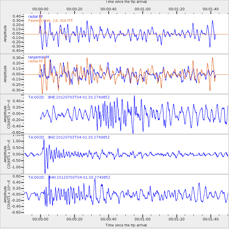
O03D Paynes Creek, CA, USA - Earthquake Result Viewer
*The percent match for this event was below the threshold and hence no stack was calculated.
| Earthquake location: |
Solomon Islands |
| Earthquake latitude/longitude: |
-10.8/163.3 |
| Earthquake time(UTC): |
2012/07/03 (185) 03:49:33 GMT |
| Earthquake Depth: |
92 km |
| Earthquake Magnitude: |
5.6 MB, 5.5 MW, 5.5 MW |
| Earthquake Catalog/Contributor: |
WHDF/NEIC |
|
| Network: |
TA USArray Transportable Network (new EarthScope stations) |
| Station: |
O03D Paynes Creek, CA, USA |
| Lat/Lon: |
40.29 N/121.80 W |
| Elevation: |
968 m |
|
| Distance: |
85.6 deg |
| Az: |
47.773 deg |
| Baz: |
252.015 deg |
| Ray Param: |
$rayparam |
*The percent match for this event was below the threshold and hence was not used in the summary stack. |
|
| Radial Match: |
69.463326 % |
| Radial Bump: |
400 |
| Transverse Match: |
60.86815 % |
| Transverse Bump: |
400 |
| SOD ConfigId: |
463687 |
| Insert Time: |
2013-02-20 18:58:08.142 +0000 |
| GWidth: |
2.5 |
| Max Bumps: |
400 |
| Tol: |
0.001 |
|
Signal To Noise
| Channel | StoN | STA | LTA |
| TA:O03D: :BHZ:20120703T04:01:30.274985Z | 6.4509134 | 6.0164786E-7 | 9.3265534E-8 |
| TA:O03D: :BHN:20120703T04:01:30.274985Z | 1.5599613 | 1.5491048E-7 | 9.930405E-8 |
| TA:O03D: :BHE:20120703T04:01:30.274985Z | 1.698357 | 1.964917E-7 | 1.15695165E-7 |
| Arrivals |
| Ps | |
| PpPs | |
| PsPs/PpSs | |


