You are here: Home > Network List > IU - Global Seismograph Network (GSN - IRIS/USGS) Stations List
> Station SBA Scott Base, Antarctica > Earthquake Result Viewer
SBA Scott Base, Antarctica - Earthquake Result Viewer
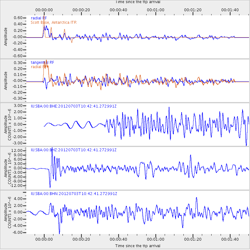
| Earthquake location: |
Cook Strait, New Zealand |
| Earthquake latitude/longitude: |
-40.0/173.8 |
| Earthquake time(UTC): |
2012/07/03 (185) 10:36:15 GMT |
| Earthquake Depth: |
230 km |
| Earthquake Magnitude: |
5.9 MB, 6.3 MW, 6.3 MW |
| Earthquake Catalog/Contributor: |
WHDF/NEIC |
|
| Network: |
IU Global Seismograph Network (GSN - IRIS/USGS) |
| Station: |
SBA Scott Base, Antarctica |
| Lat/Lon: |
77.85 S/166.76 E |
| Elevation: |
50 m |
|
| Distance: |
38.0 deg |
| Az: |
182.4 deg |
| Baz: |
8.732 deg |
| Ray Param: |
0.07489507 |
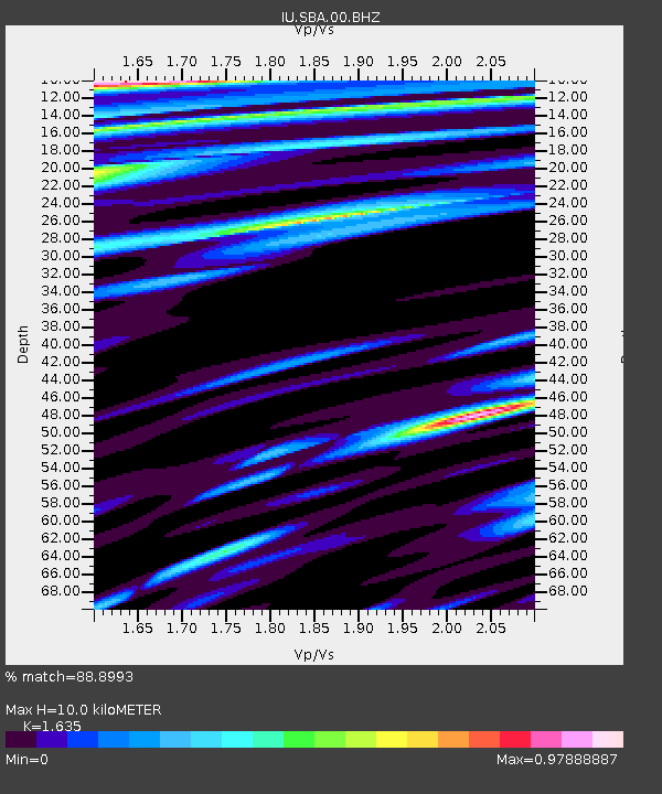
| Estimated Moho Depth: |
10.0 km |
| Estimated Crust Vp/Vs: |
1.63 |
| Assumed Crust Vp: |
6.183 km/s |
| Estimated Crust Vs: |
3.781 km/s |
| Estimated Crust Poisson's Ratio: |
0.20 |
|
| Radial Match: |
88.8993 % |
| Radial Bump: |
400 |
| Transverse Match: |
72.74076 % |
| Transverse Bump: |
400 |
| SOD ConfigId: |
463687 |
| Insert Time: |
2013-02-20 19:08:46.493 +0000 |
| GWidth: |
2.5 |
| Max Bumps: |
400 |
| Tol: |
0.001 |
|
Signal To Noise
| Channel | StoN | STA | LTA |
| IU:SBA:00:BHZ:20120703T10:42:41.272991Z | 30.677595 | 5.6205176E-6 | 1.8321246E-7 |
| IU:SBA:00:BHN:20120703T10:42:41.272991Z | 3.4004421 | 1.2038013E-6 | 3.5401317E-7 |
| IU:SBA:00:BHE:20120703T10:42:41.272991Z | 1.2688144 | 3.9292965E-7 | 3.0968252E-7 |
| Arrivals |
| Ps | 1.1 SECOND |
| PpPs | 4.0 SECOND |
| PsPs/PpSs | 5.1 SECOND |


