You are here: Home > Network List > G - GEOSCOPE Stations List
> Station SSB Saint Sauveur Badole, France > Earthquake Result Viewer
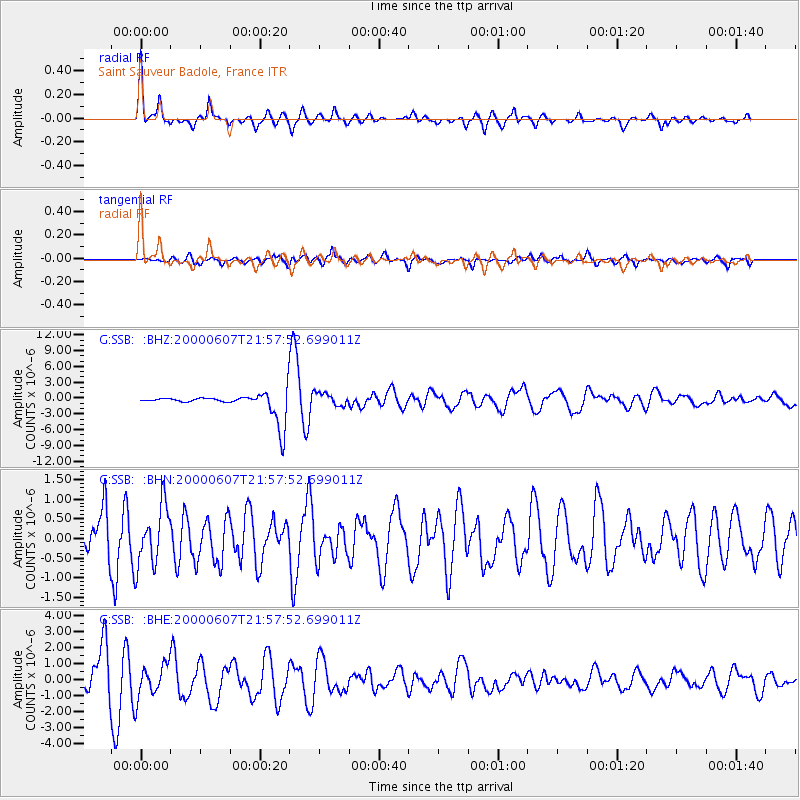
SSB Saint Sauveur Badole, France - Earthquake Result Viewer

| Earthquake location: |
Myanmar |
| Earthquake latitude/longitude: |
26.9/97.2 |
| Earthquake time(UTC): |
2000/06/07 (159) 21:46:55 GMT |
| Earthquake Depth: |
33 km |
| Earthquake Magnitude: |
6.3 MB, 6.5 MS, 6.4 MW, 6.4 MW |
| Earthquake Catalog/Contributor: |
WHDF/NEIC |
|
| Network: |
G GEOSCOPE |
| Station: |
SSB Saint Sauveur Badole, France |
| Lat/Lon: |
45.28 N/4.54 E |
| Elevation: |
700 m |
|
| Distance: |
73.2 deg |
| Az: |
312.559 deg |
| Baz: |
68.751 deg |
| Ray Param: |
0.053093836 |
| Estimated Moho Depth: |
27.0 km |
| Estimated Crust Vp/Vs: |
1.71 |
| Assumed Crust Vp: |
6.1 km/s |
| Estimated Crust Vs: |
3.567 km/s |
| Estimated Crust Poisson's Ratio: |
0.24 |
|
| Radial Match: |
91.72346 % |
| Radial Bump: |
380 |
| Transverse Match: |
85.155426 % |
| Transverse Bump: |
400 |
| SOD ConfigId: |
3744 |
| Insert Time: |
2010-02-27 00:13:00.747 +0000 |
| GWidth: |
2.5 |
| Max Bumps: |
400 |
| Tol: |
0.001 |
|
Signal To Noise
| Channel | StoN | STA | LTA |
| G:SSB: :BHN:20000607T21:57:52.699011Z | 2.547714 | 7.385012E-7 | 2.8986818E-7 |
| G:SSB: :BHE:20000607T21:57:52.699011Z | 1.3048939 | 9.990374E-7 | 7.6560826E-7 |
| G:SSB: :BHZ:20000607T21:57:52.699011Z | 0.649171 | 1.343447E-6 | 2.069481E-6 |
| Arrivals |
| Ps | 3.2 SECOND |
| PpPs | 12 SECOND |
| PsPs/PpSs | 15 SECOND |


