You are here: Home > Network List > TA - USArray Transportable Network (new EarthScope stations) Stations List
> Station 435B Jarrell, TX, USA > Earthquake Result Viewer
435B Jarrell, TX, USA - Earthquake Result Viewer
*The percent match for this event was below the threshold and hence no stack was calculated.
| Earthquake location: |
Azores Islands Region |
| Earthquake latitude/longitude: |
42.1/-29.3 |
| Earthquake time(UTC): |
2014/05/26 (146) 19:43:14 GMT |
| Earthquake Depth: |
7.1 km |
| Earthquake Magnitude: |
5.0 MW |
| Earthquake Catalog/Contributor: |
ISC/ISC |
|
| Network: |
TA USArray Transportable Network (new EarthScope stations) |
| Station: |
435B Jarrell, TX, USA |
| Lat/Lon: |
30.78 N/97.58 W |
| Elevation: |
248 m |
|
| Distance: |
54.8 deg |
| Az: |
281.785 deg |
| Baz: |
57.858 deg |
| Ray Param: |
$rayparam |
*The percent match for this event was below the threshold and hence was not used in the summary stack. |
|
| Radial Match: |
44.87419 % |
| Radial Bump: |
400 |
| Transverse Match: |
44.94811 % |
| Transverse Bump: |
400 |
| SOD ConfigId: |
3390531 |
| Insert Time: |
2019-04-12 01:21:32.095 +0000 |
| GWidth: |
2.5 |
| Max Bumps: |
400 |
| Tol: |
0.001 |
|
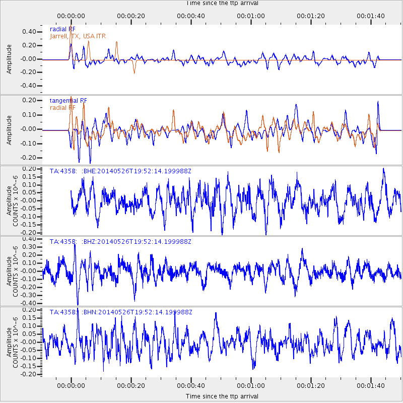
Signal To Noise
| Channel | StoN | STA | LTA |
| TA:435B: :BHZ:20140526T19:52:14.199988Z | 2.0346627 | 1.7435939E-7 | 8.569449E-8 |
| TA:435B: :BHN:20140526T19:52:14.199988Z | 1.8889246 | 7.9380214E-8 | 4.2024027E-8 |
| TA:435B: :BHE:20140526T19:52:14.199988Z | 1.3381099 | 7.723584E-8 | 5.7720104E-8 |
| Arrivals |
| Ps | |
| PpPs | |
| PsPs/PpSs | |


