You are here: Home > Network List > TA - USArray Transportable Network (new EarthScope stations) Stations List
> Station I61A Oroboro, Fairlee, VT, USA > Earthquake Result Viewer
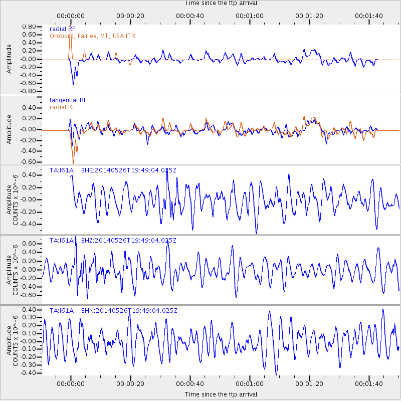
I61A Oroboro, Fairlee, VT, USA - Earthquake Result Viewer
*The percent match for this event was below the threshold and hence no stack was calculated.
| Earthquake location: |
Azores Islands Region |
| Earthquake latitude/longitude: |
42.1/-29.3 |
| Earthquake time(UTC): |
2014/05/26 (146) 19:43:14 GMT |
| Earthquake Depth: |
7.1 km |
| Earthquake Magnitude: |
5.0 MW |
| Earthquake Catalog/Contributor: |
ISC/ISC |
|
| Network: |
TA USArray Transportable Network (new EarthScope stations) |
| Station: |
I61A Oroboro, Fairlee, VT, USA |
| Lat/Lon: |
43.93 N/72.21 W |
| Elevation: |
287 m |
|
| Distance: |
31.2 deg |
| Az: |
288.17 deg |
| Baz: |
78.226 deg |
| Ray Param: |
$rayparam |
*The percent match for this event was below the threshold and hence was not used in the summary stack. |
|
| Radial Match: |
59.351437 % |
| Radial Bump: |
400 |
| Transverse Match: |
38.052605 % |
| Transverse Bump: |
400 |
| SOD ConfigId: |
3390531 |
| Insert Time: |
2019-04-12 01:21:54.836 +0000 |
| GWidth: |
2.5 |
| Max Bumps: |
400 |
| Tol: |
0.001 |
|
Signal To Noise
| Channel | StoN | STA | LTA |
| TA:I61A: :BHZ:20140526T19:49:04.025Z | 1.4605105 | 3.022558E-7 | 2.0695217E-7 |
| TA:I61A: :BHN:20140526T19:49:04.025Z | 1.5900812 | 1.9682415E-7 | 1.2378246E-7 |
| TA:I61A: :BHE:20140526T19:49:04.025Z | 1.4282999 | 2.371098E-7 | 1.660084E-7 |
| Arrivals |
| Ps | |
| PpPs | |
| PsPs/PpSs | |


