You are here: Home > Network List > G - GEOSCOPE Stations List
> Station SSB Saint Sauveur Badole, France > Earthquake Result Viewer
SSB Saint Sauveur Badole, France - Earthquake Result Viewer
| Earthquake location: |
Bonin Islands, Japan Region |
| Earthquake latitude/longitude: |
28.9/139.6 |
| Earthquake time(UTC): |
2000/08/06 (219) 07:27:12 GMT |
| Earthquake Depth: |
395 km |
| Earthquake Magnitude: |
6.3 MB, 7.3 MW, 7.3 MW |
| Earthquake Catalog/Contributor: |
WHDF/NEIC |
|
| Network: |
G GEOSCOPE |
| Station: |
SSB Saint Sauveur Badole, France |
| Lat/Lon: |
45.28 N/4.54 E |
| Elevation: |
700 m |
|
| Distance: |
95.6 deg |
| Az: |
329.898 deg |
| Baz: |
38.545 deg |
| Ray Param: |
0.04036443 |
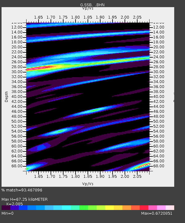
| Estimated Moho Depth: |
67.25 km |
| Estimated Crust Vp/Vs: |
2.09 |
| Assumed Crust Vp: |
6.1 km/s |
| Estimated Crust Vs: |
2.926 km/s |
| Estimated Crust Poisson's Ratio: |
0.35 |
|
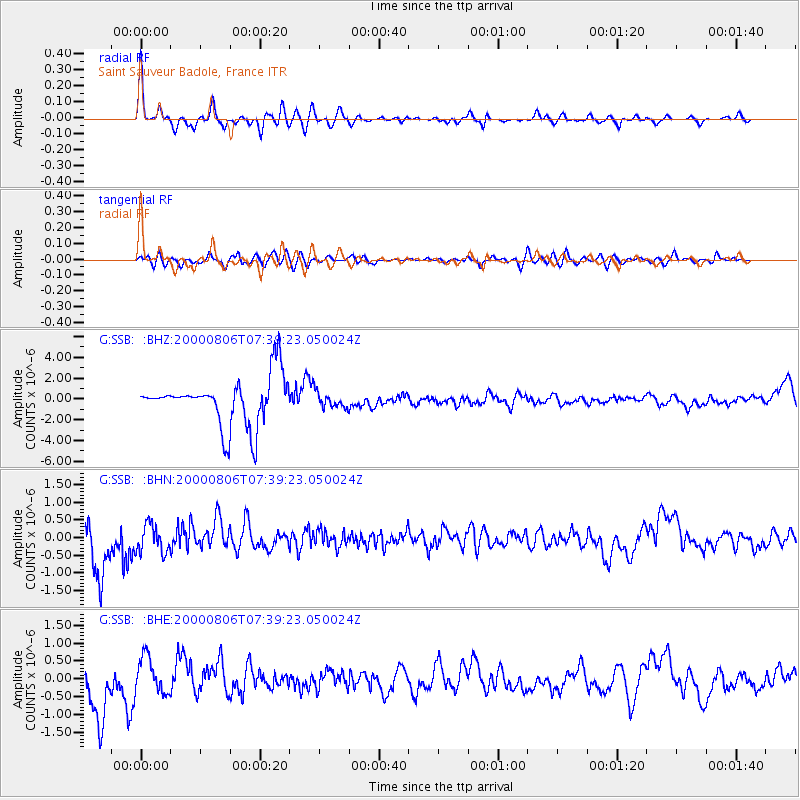
| Radial Match: |
93.467896 % |
| Radial Bump: |
380 |
| Transverse Match: |
80.897705 % |
| Transverse Bump: |
400 |
| SOD ConfigId: |
3744 |
| Insert Time: |
2010-02-27 00:13:08.668 +0000 |
| GWidth: |
2.5 |
| Max Bumps: |
400 |
| Tol: |
0.001 |
|
Signal To Noise
| Channel | StoN | STA | LTA |
| G:SSB: :BHN:20000806T07:39:23.050024Z | 0.6884486 | 3.907617E-7 | 5.675975E-7 |
| G:SSB: :BHE:20000806T07:39:23.050024Z | 0.9221204 | 5.086167E-7 | 5.51573E-7 |
| G:SSB: :BHZ:20000806T07:39:23.050024Z | 0.32303694 | 7.4029623E-7 | 2.2916765E-6 |
| Arrivals |
| Ps | 12 SECOND |
| PpPs | 34 SECOND |
| PsPs/PpSs | 46 SECOND |


