You are here: Home > Network List > CB - China National Seismic Network Stations List
> Station HEH Heihe,Heilongjiang Province > Earthquake Result Viewer
HEH Heihe,Heilongjiang Province - Earthquake Result Viewer

| Earthquake location: |
Vanuatu Islands |
| Earthquake latitude/longitude: |
-14.7/167.3 |
| Earthquake time(UTC): |
2012/07/06 (188) 02:28:22 GMT |
| Earthquake Depth: |
160 km |
| Earthquake Magnitude: |
5.7 MB, 6.3 MW, 6.3 MW |
| Earthquake Catalog/Contributor: |
WHDF/NEIC |
|
| Network: |
CB China National Seismic Network |
| Station: |
HEH Heihe,Heilongjiang Province |
| Lat/Lon: |
50.25 N/127.41 E |
| Elevation: |
165 m |
|
| Distance: |
73.5 deg |
| Az: |
334.553 deg |
| Baz: |
139.621 deg |
| Ray Param: |
0.05253027 |
| Estimated Moho Depth: |
28.75 km |
| Estimated Crust Vp/Vs: |
1.92 |
| Assumed Crust Vp: |
6.419 km/s |
| Estimated Crust Vs: |
3.339 km/s |
| Estimated Crust Poisson's Ratio: |
0.31 |
|
| Radial Match: |
96.774315 % |
| Radial Bump: |
292 |
| Transverse Match: |
90.93778 % |
| Transverse Bump: |
400 |
| SOD ConfigId: |
463687 |
| Insert Time: |
2013-02-20 19:15:35.853 +0000 |
| GWidth: |
2.5 |
| Max Bumps: |
400 |
| Tol: |
0.001 |
|
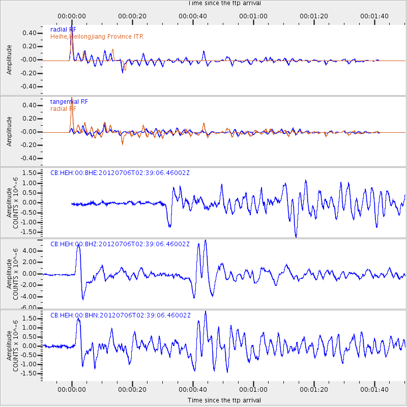
Signal To Noise
| Channel | StoN | STA | LTA |
| CB:HEH:00:BHZ:20120706T02:39:06.46002Z | 44.066994 | 2.8794148E-6 | 6.534176E-8 |
| CB:HEH:00:BHN:20120706T02:39:06.46002Z | 21.348988 | 7.757003E-7 | 3.633429E-8 |
| CB:HEH:00:BHE:20120706T02:39:06.46002Z | 12.046287 | 5.885893E-7 | 4.8860638E-8 |
| Arrivals |
| Ps | 4.3 SECOND |
| PpPs | 13 SECOND |
| PsPs/PpSs | 17 SECOND |


